Southern States Brace for Snow and Ice: A Detailed Forecast
A winter storm will bring a prolonged period of wintry precipitation between now and Tuesday across parts of the Mid-South, Southeast, Tennessee Valley, and the lower-mid Appalachians. The winter storm has already begun to take shape farther west across the Southern Plains and Arkansas, and wintry precipitation will begin to develop east/northeast from there in the coming hours.
Brief Synopsis of Overall Pattern
A very cold airmass will continue to infiltrate southeastward and get further reinforced by an incoming, potent shortwave dropping into Montana and Wyoming on Monday. At the same time, two shortwaves, both of which entered Oregon and northern California, will trek along the base of a broad trough over the U.S., enhancing upward motion in the atmosphere across a southwest-to-northeast oriented zone. Additionally, the orientation of a jet streak and low to mid-level warm advection will favor further enhancement for precipitation development (mostly snow) across a region extending from the Mid-South, Tennessee, the lower Appalachians, and parts of the Mid-Atlantic, today into tomorrow. Precipitation will also develop farther south, bringing an icy mess to parts of the Deep South.
Snow Forecast & Discussion
Wintry precipitation has already developed across Oklahoma/eastern Texas and Arkansas and now has begun to extend into western Tennessee, lower Missouri, and even northern Mississippi. Precipitation is mostly reaching the ground as snow, per observational reports.
Snow will continue to fill in across northern Mississippi, Tennessee, and far northern Alabama throughout today into tonight and eventually extend into Kentucky, Virginia, West Virginia, the far northwest corner of Georgia, and the lower Appalachians tonight and early Monday.
A moderate to heavy band of snowfall accumulations will most likely occur from south-central Arkansas, northern Mississippi, far northern Alabama, much of Tennessee (except NW TN), and extending into southeastern Kentucky, southwestern Virginia, and West Virginia. This region will find itself positioned underneath favorable dynamics and thermodynamics and also likely remain cold enough through the entire atmospheric column to support mostly a snow event (though a transition to sleet/freezing rain could occur Monday night). Additionally, rain-to-snow ratios will be above average for this event, and given the long duration of snowfall expected, a large swath of 4-6+ snow accumulations will likely occur. Some areas across northern Mississippi, east-central Arkansas, and far southwestern & eastern/northeastern Tennessee will have the highest chance of reaching the 8-10 inch range with isolated areas approaching a foot.
Far southeast Tennessee, which includes Chattanooga, and far northwest Georgia remain a bit of a wildcard. It will take a little longer for snow to begin across those areas, but when it does, it should come down at a decent pace, especially on Monday. A low-level warm-nose will work its way into the area Monday night into Tuesday, changing precipitation-type to a mixed bag. Even with the better snow-to-liquid ratios being just north and northwest and the possibility of a change-over to ice, Chattanooga and far northwest Georgia still should manage to get a solid 2-4 inches of snow accumulations.
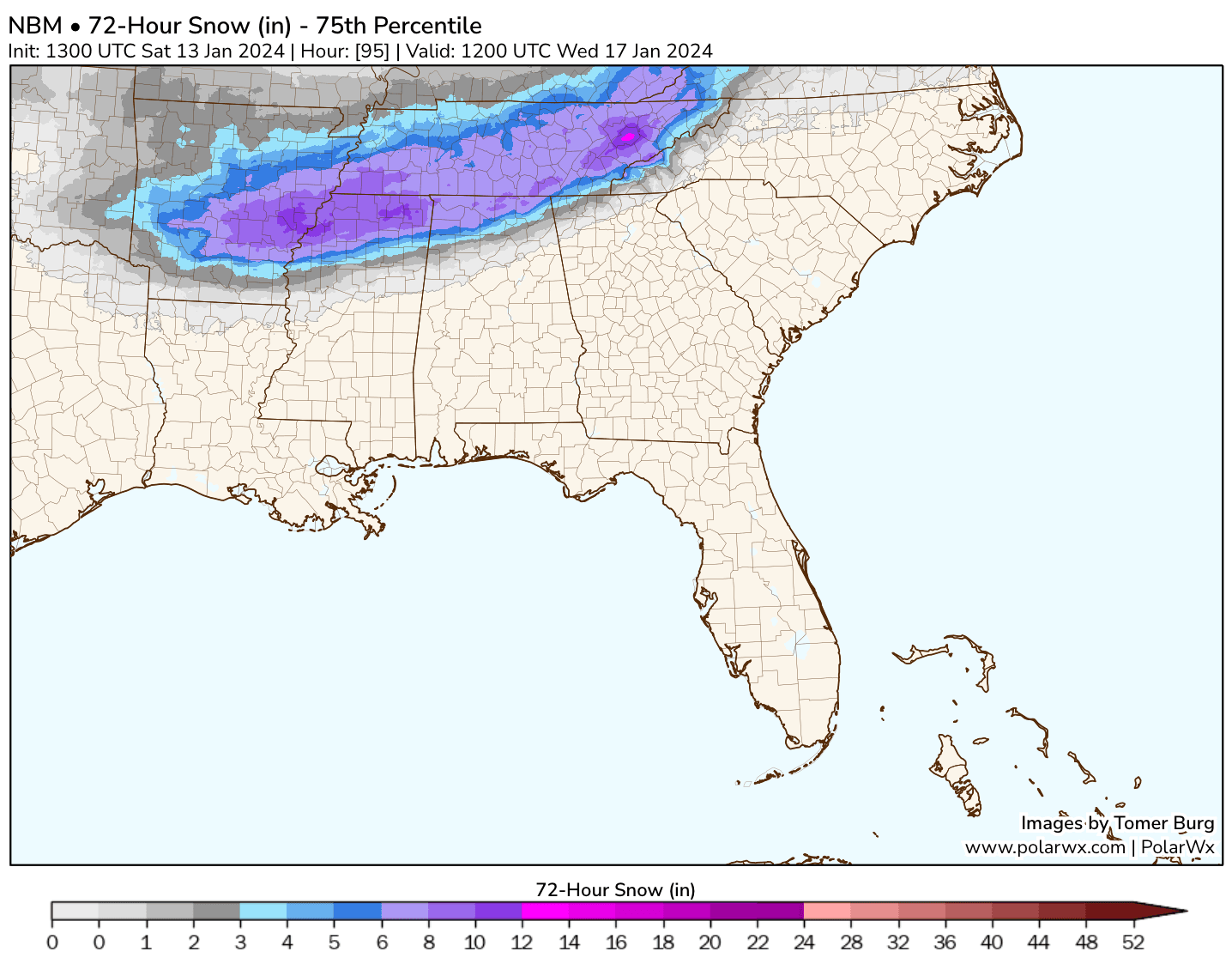
72-Hour Snow Accumulation Forecast (most likely to occur if all-snow event and at least moderate snow rate)
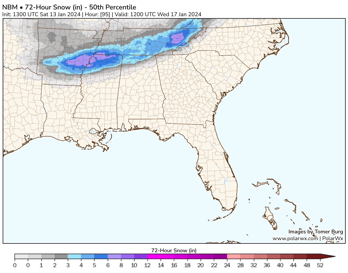
72-Hour Snow Accumulation Forecast (most likely to occur if warm nose is farther north and causes transition to sleet/freezing rain)
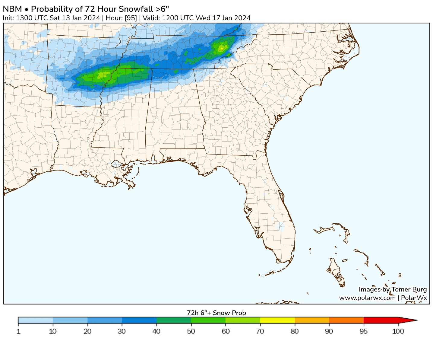
Probability of receiving 6-inch snow accumulations or more
Ice Forecast & Discussion
Unfortunately, this winter storm will bring mostly ice (sleet/freezing) to eastern & south-central Texas, lower Arkansas, Louisiana, central/lower Mississippi, and northern/central Alabama (generally south of Huntsville). With southwesterly flow in the low and mid-levels, a stout warm nose will work its way northeastward, overrunning the colder, Arctic air at the surface. Surface temperatures will stay at or below freezing across these areas but not aloft. So, no snow for residents in these regions, only nasty ice.
The farther southeast one goes, the lighter the precipitation will likely be. However, even light precipitation will result in icy accumulations in the mentioned regions, even if a glaze. It's also worth noting that sometimes you can't even tell there's ice on the road if the predominant precipitation type is freezing rain.
We are monitoring the potential for some light wintry precipitation to fall early Tuesday as far southeast as the northwest metro of Atlanta. If this occurs, it'll be at the tail end of this event; however, even a glaze would become problematic, especially during the Tuesday morning rush hour.
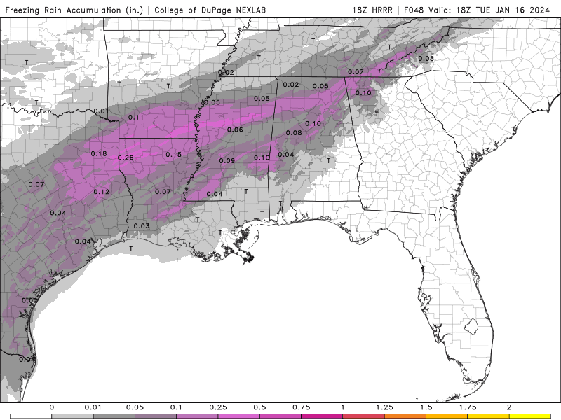
Freezing rain accumulation forecast from the most recent extended HRRR model
Firsthand Weather Newsletter Sign-up