Christmas Eve Tornado and Severe Weather Threat Looking More Likely
UPDATE: I made a big mistake, and one of my viewers pointed it out. This event is going to occur this WEDNESDAY, not on Christmas Eve. For whatever reason, I had my days mixed up. Sorry about that. Instead of going and changing every mention of Christmas Eve, just know that it’s supposed to be Wednesday, not Christmas Eve.
An interesting situation is definitely shaping up for Christmas Eve, and while there are definitely a couple of uncertainties that I’ll discuss momentarily, severe weather, including the risk for tornadoes, is looking more likely for areas of the South including parts of the Mississippi Valley and Tennessee Valley.
Detailed Analysis:
A broad mid-to-upper level trough is going to continue to build into the western United States while persistent ridging along the eastern United States is going to remain intact. A piece of energy is going to move into the United States, which is currently embedded in the westerly (west-to-east) wind flow over the northern Pacific. Once this piece of energy swings southeastward and becomes embedded in the western U.S. trough, this will trigger a surface low pressure system to most likely develop east of the Rockies, which will eventually shoot northeast towards the Great Lakes. To put it simply, all I’m really saying is that the mid and upper-level atmosphere is going to be favorable for the development of a low-pressure system at the surface.
Notice the broad trough located over the west-central U.S. on Wednesday with the ridge along the East Coast. Sorry for not actually including an explanation on the map to make this more understandable.
A cold front is currently moving across the U.S., which is associated with an entirely different low-pressure system, but this front will eventually push back northward as a warm front. Anytime there is a western trough, eastern ridge setup like this, it always gets my attention for possible severe weather in between. With the very strong Pacific jet stream (winds in the upper atmosphere) that has been responsible for bringing in the parade of storm systems into the Pacific Northwest, it’s important to keep a close eye on any embedded pieces of energy that could bring some issues later down the road.
The pattern has remained overwhelmingly warmer across the eastern half of the United States this December. A strong and well-placed polar vortex remains intact over the North Pole, which supports this warmth over many regions. The Pacific and much of the Atlantic, including the Gulf of Mexico and waters off the East Coast, remain well-above average. Despite the winter season that is upon us, bodies of water do not lose heat nearly as quickly and warm the air above. Without any substantial Arctic air masses moving southward, it simply stays warm because all of that warmth gets transported eastward due to the wind flow. This particular year, the Pacific is almost unprecedentedly warm. Hopefully this makes sense and isn’t getting too confusing. Please let me know if it is!
Who Will Be Impacted?
So back to this low pressure system that I mentioned would develop! As it moves northeast, all of this warmth and moisture is going to get transported northward from the Gulf of Mexico into the warm sector of this system. With the combination of this warmth and moisture, the low and mid-to-upper level winds are going to be favorable for severe weather, including tornadoes, to develop on Christmas Eve across parts of the Mississippi Valley and Tennessee Valley. The tornado threat will be for parts of Mississippi, Alabama, Arkansas, Tennessee, Louisiana, and Texas. Georgia also needs to keep an eye on this situation in case the threat extends longer into the overnight hours on Christmas Eve. Surrounding states need to monitor all of this closely also, and I wouldn’t be surprised if additional regions have to be included in a risk zone.
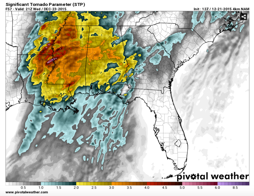
Significant Tornado Parameter Map For Late Afternoon:
Note: This is a multi-component index that takes several factors into account. Brighter colors indicate a higher risk for a given area to have storms capable of producing tornadoes.
Significant Tornado Parameter Map For Early Evening:
A tongue of drier air is going to likely work its way into the mid levels of the atmosphere across parts of Louisiana, Mississippi and Alabama on Wednesday and eventually extend northward. Believe it or not, this actually makes the atmosphere more unstable than it otherwise would be. I won’t get into the reasoning behind all of that, but it can promote the development of deep convection (thunderstorms).
Here’s my biggest uncertainty at this point. Leftover thunderstorms from Tuesday could be over the region of concern going into Wednesday. This could keep the atmosphere more stable than expected, but that is very difficult to predict. Generally, I warn my audience not to count on that occurring, and try to prepare as many people as possible. With this kind of setup, it’s only going to take a couple of hours of sunlight to destabilize atmosphere enough to allow for this event to unfold.
With all of that said, a tornado outbreak is not out of the question at this point, and the areas that I just mentioned need to be on high alert and make adequate preparations now. This will be an event that could continue as it becomes dark. If you’ll be traveling, please check the weather frequently.
Storm Prediction Center’s Latest Outlook For Christmas Eve:
Flooding Threat:
Deep tropical moisture will be pushing northward as the warm front moves northward. A sub-tropical jet stream that will be cutting across Mexico and extending northeastward into the Southeastern U.S. will be responsible for transporting deep moisture well to the north into parts of the eastern United States. I posted WPC’s latest predicted 3-Day rainfall totals to give a general idea of which areas could get the highest rainfall totals.
Latest Projected 3-Day Rainfall Totals From WPC:


