A potentially significant severe weather event is expected to unfold Friday
Eyeing the potential for significant severe weather for parts of the Mid-South, Tennessee Valley, and Ohio Valley Friday as a strong storm system sweeps across the country. Severe storms are expected to develop along a cold front late in the day Friday across eastern Oklahoma and eastern Texas, sweeping east Friday evening and overnight Friday.
These storms will likely quickly become strong to severe producing gusty winds, hail, and a few tornadoes. As the storms continue during the evening and overnight hours, a strong low-level jet is expected to develop, helping increase the tornado potential. Thus, nocturnal tornadoes are expected Friday night from the Mid-South, northeast into the Ohio Valley. A couple of strong tornadoes are possible.
The coverage and intensity of the storms have prompted the Storm Prediction Center to place parts of eastern Arkansas, northern Mississippi, western Tennessee, southeastern Missouri, southern Illinois, southern Indiana, and western Kentucky in an enhanced severe risk (level 3 of 5) for Friday night. It’s possible parts of this are upgraded to a moderate-severe risk (level 4 of 5) later tonight.
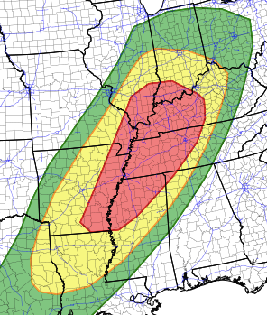
Friday severe risk
Below, the graphics show the tornado, hail, and wind risks for the region. Notice the yellow, hashed area where the enhanced risk exists. This is where the is the highest potential for tornadoes Friday evening with the possibility of a few becoming severe.
Friday tornado risk
Friday hail risk
Friday wind risk
If you’re in any of the severe risk areas tomorrow (marginal, slight, or enhanced), please go ahead and have a plan in place in case a warning is issued for your area.