Summer Cool Front And Rain Chances For Southern Plains And Southeast
The pattern has been on repeat across the Southern Plains over the past couple of weeks. While the upper level high is the predominant weather feature (which is responsible for the hot conditions), another cool front will push into northern Oklahoma Thursday afternoon as an upper level trough moves across the Plains. This cool front should advance southward through central Oklahoma. The front’s movement is highly dependent upon thunderstorm activity. The more storms that develop, the further south the front will be pushed.
Isolated severe thunderstorms are possible Thursday afternoon along this front. The main threats are damaging winds and large hail; however, an isolated tornado is possible before storms develop into a complex. The Storm Prediction Center (SPC) has a slight risk of severe thunderstorms for locations along the cool front.

SPC Thunderstorm Forecast Thursday Afternoon
Friday, more rain chances are likely and appear to be more widespread. Friday’s forecast is very ‘murky’ right now. It’s possible that Thursday’s thunderstorms could send the cool front, and an associated outflow boundary, pretty far southward into the Red River Valley. This, coupled with remnant outflow boundaries will give all of Oklahoma and northern Texas thunderstorm chances. The models cannot handle these scenarios this far in advance very well. The Texas Tech WRF is hinting at this scenario, and has handled these patterns very well as of late.

Texas Tech WRF Friday Afternoon
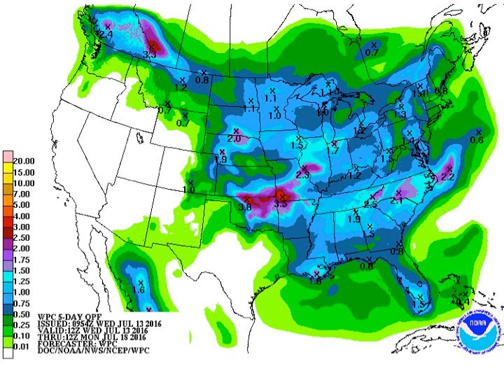
Northern Oklahoma/southern Kansas will also see thunderstorm chances Friday; there are strong signals from guidance that a MCS will develop and impact this area. These areas may see flooding concerns develop due to Thursday’s rainfall. Widespread 1-2″ of rainfall are possible north of I-40–isolated 3-4″ are possible.

Rainfall Forecast (Next Five Days)

Hi Res NAM Rainfall Forecast
The aforementioned upper level trough (that will send the cool front into Oklahoma) will advance eastward, which will temporarily weaken the persistent ridge across the Southeastern United States. This will create favorable conditions for thunderstorms for this region. Rain chances are possible for this region through Friday due to sea-breeze activity, but greater coverage can be expected by the weekend. If you have outdoor plans, please remain alert. These storms will produce gusty winds, frequent lightning, and very heavy rainfall.

NAM Rainfall Forecast
Even with the increased rain chances across both regions, temperatures will remain hot (in the 90’s). Stay hydrated!