Bill Expected To Blast Texas And Oklahoma
Tropical Storm Bill is continuing to trek northward across the state of Texas this evening. Per the latest advisory from the National Hurricane Center (NHC), Bill has maximum sustained winds of 40mph and is moving due north at close to 12mph. Bill will continue to move northward overnight, which will increase rain chances for central and southern parts of northern Texas by early tomorrow morning. Some homeowners and business property owners may find their properties and belongings such as cars become damaged, if this is the case you’ll want to get in touch with repair services such as roof repair Cedar park and other repair services to ensure you have a place to sleep at night.
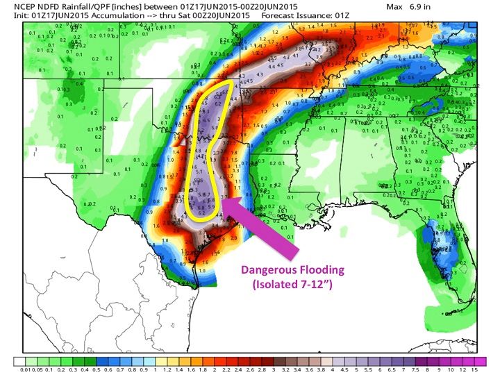
As Bill slowly transitions into a Tropical Depression tomorrow, rain will begin to impact the rest of northern Texas and southern Oklahoma. The primary threat with Bill is flooding. Flooding is already taking place across southern Texas tonight and will continue overnight. Bill is dumping copious amounts of rainfall close to the center of the storm; rainfall rates are between 2-5″ per hour. The areas that will see the heaviest rainfall overnight are locations south of I-20 and east of I-35 in Texas. This is because, at night, inland tropical cyclones tend to see a reduction in the size of their rain-shield due to cooling and other environmental processes. This does NOT mean Bill is falling apart! The rain actually tends to be heavier with inland tropical cyclones at night; however, the rain is in a more compact area (immediately around the center of the cyclone–the precip shield will expand once the sun rises and the Earth’s surface begins to warm). The aforementioned areas overnight will see 3-7″ of rainfall. By early tomorrow morning, Bill will continue its northerly trek and spread precipitation into all of northern Texas and eastern Oklahoma. Rainfall will be very heavy at times and over the next couple of days (Wednesday-Thursday), northern Texas and all of eastern Oklahoma may pick up widespread 4-7″ of rain with isolated 7-13″ amounts.
Forecast Rainfall Totals For The Next Three Days:

I cannot leave out the tornado and wind threat. While flooding is the main concern, a few tornadoes are possible with Bill–especially tomorrow morning across northern Texas/southern Oklahoma. CAPE values should begin to increase at this point, coupled with very favorable 0-1KM helicity values, which should aid in large looping hodographs. Any tornado that develops will be weak and brief, but even an EF0-EF1 tornado can still cause damage and is very dangerous. The greatest tornado threat with inland tropical cyclones is in the front-right quadrant of the storm so locations east of I-35 have threat highest tornado threat. A few damaging wind gusts are also possible if some of the high winds associated with Bill are able to mix down to the surface.
Greatest Tornado Threat (Bill near Dallas tomorrow morning–HWRF):

**
Greatest Tornado Threat (Bill south of the Red River tomorrow afternoon–HWRF):

Bill near Oklahoma City Thursday morning–HWRF:

**
Tornado Watch Through Midnight tonight (For Areas Outlined In Red):

One last observation I would like to address is the latest guidance is trending towards a slower progression of Bill once he moves towards the Red River into Oklahoma. This trend is alarming, however premature at this point, because if Bill slows down/temporarily stalls, then copious amounts of rain could fall across eastern Oklahoma and far northern Texas. Please note, I am not saying this will happen, but the last few runs of the NAM (and the HWRF to some degree) are trying to keep Bill in Oklahoma for an extra day or two. I’ll keep an eye on this solution and have an update tomorrow.
