Several days of severe weather expected from the Southern Plains to Mid-South
March 1st was the first day of meteorological spring, and now spring-like thunderstorms are in the forecast over the next several days. Severe thunderstorms will begin over the Southern Plains and slowly spread east into the Mid-South.
The severe thunderstorm event will be triggered by the jet stream plunging south over the western-half of the lower-48. This dip in the jet stream will create a nice uptick in moisture across the western lower-48, including parts of California and the Four Corners states (YAY!). What comes down, must go up! A seesaw will take place. As the jet stream dips over the western lower-48, the jet stream will surge north over eastern parts of the country, which will lead to well above average temperatures.
This pattern will set the stage for severe thunderstorms from the Southern Plains into the Mid-South as gulf moisture and warmth feeds north, east of the Rockies, along with strong winds and colder temperatures slowly spreading east in the upper-levels of the atmosphere.
Severe thunderstorm forecast
Wednesday
The first threat for severe thunderstorms begins Wednesday across the Southern Plains. The main area to see thunderstorms will occur from western Missouri, southwest into central and eastern Kansas, down into central Oklahoma. The main hazards are gusty winds and hail.
Wednesday thunderstorm outlook
Thursday
The severe thunderstorm threat continues Thursday, slightly shifting south. The main area to see thunderstorms will occur from southern Missouri, southwest into southern Kansas, down into central and western Oklahoma as well as western Texas. The main hazards are gusty winds and hail.
Thursday thunderstorm outlook
Friday, Saturday, Sunday
A more impactful severe weather threat begins Friday, continuing through the weekend as the dip in the jet stream out west begins to move east. This will allow the hail and wind threat to continue along with an uptick in the chance for tornadoes.
The enhanced severe threat will begin Friday across far southern Kansas, northern and western Oklahoma, extending down into northwestern Texas.
The severe thunderstorm risk area expands on Saturday from southern Kansas, all of Oklahoma, down through northern and central Texas.
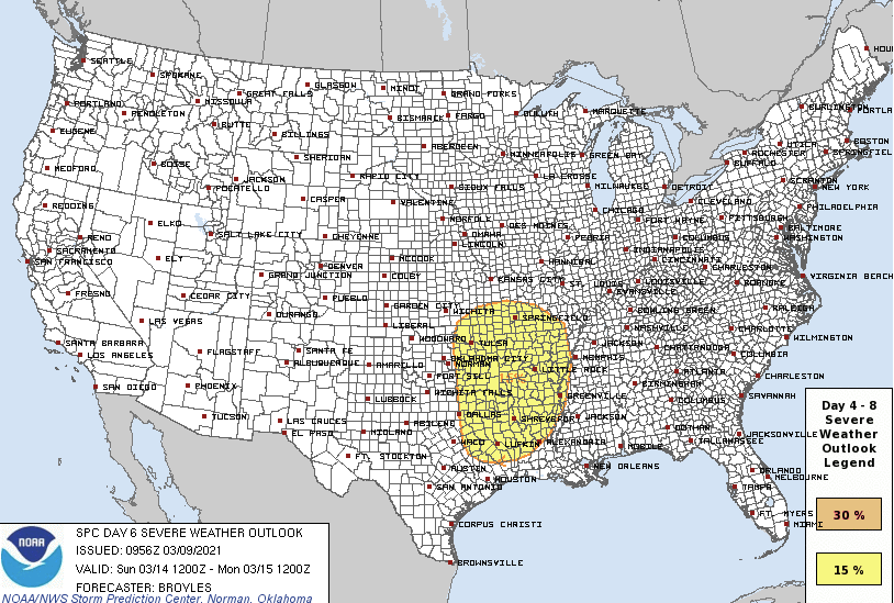
By Sunday, the severe threat slowly shifts east into the Mid-South. Eastern Kansas, southern and central Missouri, eastern Oklahoma, eastern Texas, Arkansas, northern and central Louisiana, far western Tennessee, and far northwestern Mississippi will all be under the gun for severe thunderstorms.
All modes of severe thunderstorms are possible Friday, Saturday, and Sunday.
Friday thunderstorm outlook
Saturday thunderstorm outlook
Sunday thunderstorm outlook
As the dip in the jet stream advances east early next week, the associated cold front will seep into the Ohio Valley and Southeast. The thunderstorm threat will shift east, too, but there are too many uncertainties at this point for a severe hazard to be outlined.
Keep checking back for updates!