Soon-To-Be Tropical Storm Bill Expected To Bring Widespread Flooding And Tornadoes To Texas And Oklahoma
Tropical troubles are brewing for parts of the Southern Plains and South beginning late tonight for the Texas Coast (via outer-bands of soon-to-be Tropical Storm Bill) through Thursday. The National Hurricane Center (NHC) is in the process of upgrading the low-pressure system over the Gulf of Mexico to a Tropical Storm with maximum sustained winds around 50mph. Right now, the system is in a relatively favorable upper-level environment to allow strengthening before the system moves into the middle-to-upper Texas Coast late tomorrow morning. Regardless of the intensity, this system will bring flooding rains and possibly weak tornadoes to parts of Texas, eastern Oklahoma, western Louisiana, and western Arkansas. Residents should be especially concerned about category 3 water damage, or “black water damage“, if sewerage pipes etc. become compromised in residential areas.
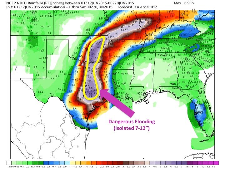
Soon-to-be Tropical Storm Bill will continue to move to the north-northwest overnight before beginning a northward trek across the state of Texas once it makes landfall. The remnants of the storm should remain intact through Texas, and into Oklahoma, spreading tropical moisture into these areas, which will exacerbate the flooding issues this region has dealt with over the past month. Flooding, of course, leads to water damage in many properties; property owners will then want to enlist the services of a company like Water Damage Restoration of Austin in order to deal with the resulting devastation. The best “guess” for the track of the center of the storm is just west of the I-35 corridor. The heaviest rain tends to fall to just to the east of the center of a cyclone, so a large area along and just east of the I-35 corridor–as well as the Texas Coast, will see several inches of rainfall through Thursday. Widespread 3-7″ rainfall accumulations look likely with some areas, especially near the Texas Coast and just east of I-35, may see isolated 7-12″+. Please note, a track difference of 50 miles to the west west or 50 miles east will have HUGE implications on this forecast.
Our Projected Rainfall Totals:
**
**
Flooding and flash flooding are the main threats and this will be a high threat; however, a few weak tornadoes (EF0-EF1) are possible as the storm moves inland. The highest threat for tornadoes with landfalling tropical cyclones is in the right-front quadrant of the cyclone. This means, going by the latest guidance of the potential storm track, areas east of I-35 have the highest chance of seeing weak, tropical tornadoes. These tornadoes will be weak, however, an EF0 or EF1 tornado can still cause damage, so do not take this threat lightly. The greatest tornado threat will be from Tuesday afternoon through Wednesday for the area; this is when the 0-1KM helicity values are forecast to be the highest along with large looping hodographs. As I stated earlier, this is a fluid situation, so a small change in the forecast track can change the area that sees the highest tornado threat.
HWRF Model Landfall Along Texas Coast (Tuesday Morning):
**
HWRF Model Moves Cyclone Near Dallas (Wednesday Morning):

HWRF Model Moves Cyclone Near OKC (Late Wednesday Night):
**
The exact timing and track of the storm are still in a gray area right now, but I will have updates as needed to fine-tune this forecast. It is also important to point out: some of the guidance is hinting at this system leaving behind some energy which could aid in more precipitation at times Thursday afternoon through Saturday. If you live 50 miles west of I-35, and all locations east of this, please prepare now for life threatening flash flooding and weak tornadoes.


