A Waste of a Storm System for Southeast Snow Lovers
As a nasty, cold rain falls, have you ever pondered what would’ve happen if all of that rain had been snow? As a snow-lover born and raised in the Southeast, it’s hard not to get a little frustrated when one or two minor yet significant ingredients don’t come together at the right time to bring a few inches of snow. We snow lovers usually upset those who dislike snow by talking about how much we want snow. It’s not like we can help that we like snow. When snow accumulates in the South outside of the mountains, it usually melts within a day or two anyway. Wow, I’m saying the word snow a lot, aren’t I?
Weekend Setup
Let’s talk about why a number of you will be disappointed by what happens late this weekend into early next week. A shortwave will continue pushing across the southern and central Plains today. This feature has induced the development of a surface low, now sitting on the Kansas/Missouri border. It will continue on a northeastward trajectory toward the Great Lakes region into early to mid-weekend. As a result, a cold front will push down to the Gulf coast from Texas to the Florida panhandle. This front will bring colder temperatures by mid to late weekend to most of the South, outside of areas at/near the Southeast coast and Florida.
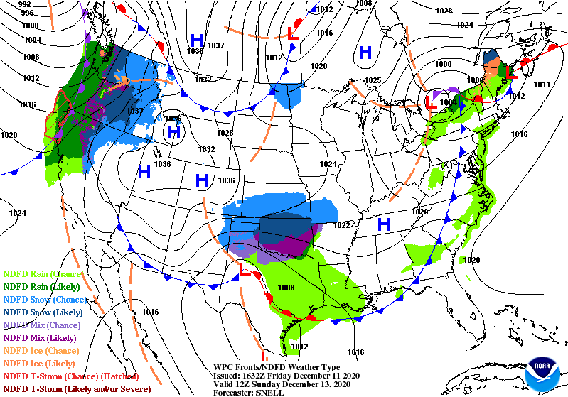
Projected surface conditions on Sunday morning, December 13, 2020
A secondary shortwave will move into the Pacific Northwest today. Early to mid-weekend, the wave will trek southeastward across the Rockies, into the Four Corners region, and then eastward into the Southern Plains. As with the first shortwave, a surface low will develop. This feature, however, will move across the lower Plains and then across the Gulf coast states late Sunday into Monday. And, here’s the thing. This low will move into the Southeast behind the cold front. This sort of setup favors winter storms impacting parts of the Mid-South, Southeast, and Tennessee. Yet in this case, snow will fall across the Cascades, much of the Rockies, the Southern Plains, and even into parts of the Mid-Atlantic, but NOT across the Southeast and most of Tennessee.
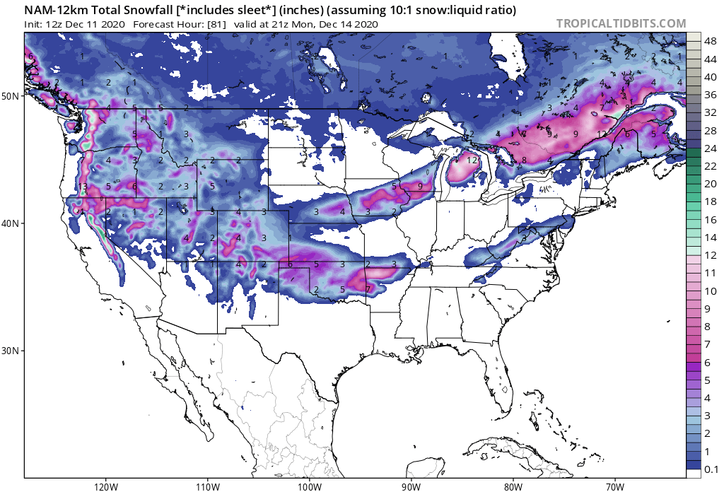
12z NAM’s projected snowfall accumulations through Monday afternoon (using 10:1 snow/rain ratio)
Why Some Will Get Snow When Others Won’t
The problem is the lack of cold air. Though the cold front will have already pushed through much of the Southeast, there won’t be enough time for sufficiently cold air to spill into the region. Earlier in the week, the European model had a couple of runs that indicated a winter storm would occur, but at the time, it depicted a stronger system. In this case, the low would’ve advected sufficiently cold air as far south as Tennessee, northern Mississippi and Alabama, far northern Georgia, and central North Carolina. Given the projected surface low track, Atlanta would’ve likely missed out anyway, but places like Memphis, TN; Nashville, TN; Chattanooga, TN; Huntsville, AL; Birmingham, AL would’ve had a significant winter event. Oh well!! Instead, get ready for more rain over the weekend.
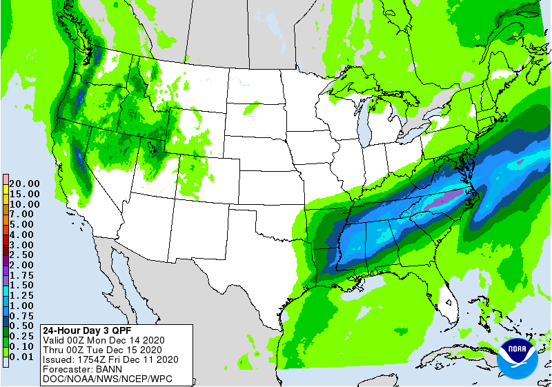
Projected rainfall amounts from Sunday evening to Monday evening
Comments on 2020-21 Winter Forecast
Throughout much of this winter, the coldest air will have a tendency to remain locked away in western/central Canada and Alaska, oftentimes only spilling into northern parts of the U.S. (check out our winter forecast for specifics). Despite this fact, much of Tennessee and the northern third of the Southeast should have a few decent chances to get wintry weather this season. However, the rest of the Southeast likely won’t fare as well. The currently active pattern across the Southeast likely won’t persist much past December, and a tendency for above average temperatures will lower those snow/ice probabilities further.
Christopher will post an article later today on potential snowfall accumulations for this Sunday and Monday across the Southern Plains and Mid-Atlantic.
Download Firsthand Weather’s Southern Snow App Today
Curious to know how much snow you will receive? Download Firsthand Weather’s new & FREE app: SOUTHERN SNOW (Link). This app has you covered this winter and will let you know how much snow is in your forecast and notify you of any winter weather alerts for your area!