High-Impact Nor’easter to Impact the Mid-Atlantic and New England
Brief Synopsis
This week’s storm system of interest has now moved away from the West Coast and begun to dig into the Four Corners region. The vigorous shortwave will continue amplifying across the Southern Plains on Tuesday. By Wednesday, it’ll begin lifting east northeastward across the Mid-South, Mississippi Valley, and Tennessee Valley. Later Wednesday, the wave will push into the Ohio Valley, the Mid-Atlantic, and New England, bringing a powerful winter storm along the East Coast from Wednesday into Thursday.
Timing
After dropping snow across the Rockies, precipitation will develop along and ahead of the shortwave across the central and southern Plains on Tuesday. The wave will trigger the development of a surface low along the Gulf coast on Wednesday, as a large swath of precipitation overspreads the Southeast, Tennessee Valley, Ohio Valley, and Mid-Atlantic. Precipitation will then begin to overspread southeastern New England by Wednesday evening, continuing into Thursday. Rain and possible storm development in the warm sector of the system will aid in the amplification of a downstream ridge. The strength of this ridge will determine how closely the surface low rides along the Mid-Atlantic and southeastern New England coast after departing North Carolina and Virginia.
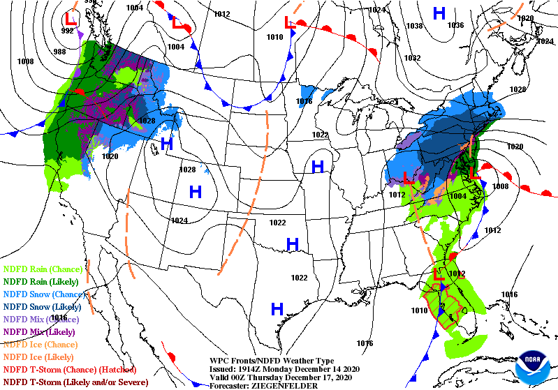
Expected position of the surface low off the Mid-Atlantic coast on Wednesday evening
Forecast Model Discussion
The operational, along with many of its ensemble members, have continued to show a more southern track of the surface low, primarily due to a weaker downstream ridge. In such a scenario, the axis of heaviest snowfall rates and accumulations would occur from around D.C. (and northern Virginia) to Philly to Long Island to Cape Cod. Areas just northwest of this line would still get noteworthy but lower amounts. The GFS-parallel, a version of the GFS still in its testing phase, has consistently been the northern outlier. This solution would largely be a miss for D.C., Philly, New York City, Long Island, and Cape Cod, but copious amounts of snow would fall northwest of this line, including over Boston.
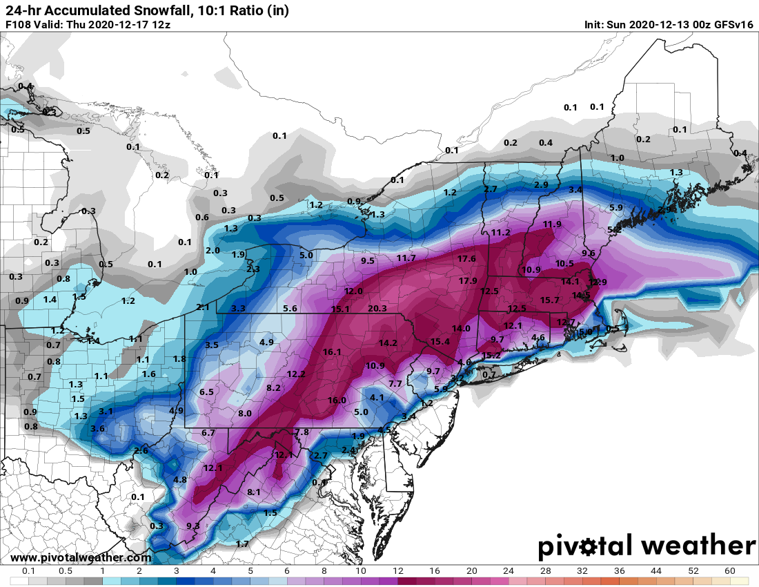
Projected 24hr Snowfall accumulations from Wednesday morning to Thursday morning, according to the GFS-parallel model. Additional snow will fall across parts of New England Thursday afternoon.
The European model, along with the shorter-range 12km NAM, has the surface low trekking quite close to the Mid-Atlantic after moving just offshore. Both models keep the low far enough off the southeastern New England coast for the heaviest snow accumulations to still fall over Philly, NYC, Long Island, and Cape Cod.
Most model guidance indicates that downstream ridging mid-week will be flattened by the current storm system exiting New England today. However, this ridge should be more amplified than what models suggest. For that reason, I gave the GFS-parallel and the shorter-range RGEM model (not discussed above) more weight in the snow accumulation forecast below. If there’s not a northward shift in most model guidance by tomorrow afternoon, I’ll adjust my forecast to align more closely with the operational GFS, European, and other short-range guidance.
Matthew’s Snowfall Accumulation Forecast for Select Cities
Washington, D.C.: 1-3 inches
Philly: 3-6 inches
New York City: 3-6 inches
Long Island: 1-3 inches
Providence, RI: 12-18 inches
Boston: 12-18 inches
Cape Cod: 1-3 inches
Download Firsthand Weather’s Southern Snow App Today
Please consider downloading Firsthand Weather’s new & FREE app: SOUTHERN SNOW (Link). This app will notify you when there are winter weather alerts in your area. Also get updates on the latest snowfall accumulations from your local National Weather Service, along with detailed forecast discussions from Firsthand Weather.