Significant Winter Storm To Likely Impact Parts of the Southeast Late Week
Synopsis
A potent shortwave will dive southeastward across the Rockies and enter the Southern Plains on Wednesday. The feature will develop into a closed low on Thursday over the Mid-South, triggering the development of a surface cyclone along the Gulf coast the same day. By early Friday, the system will reach the Georgia/South Carolina coast and trek up along the Southeast coast on Friday.
This system has a chance to bring a round of accumulating snowfall on Wednesday to far eastern Oklahoma and Kansas, northwestern Arkansas, southern/western Missouri and areas northward on Wednesday. A snowstorm will impact parts of the Southeast late Thursday into Friday, potentially including far northern Alabama and Georgia, eastern Tennessee, far southeastern Kentucky, far southern Virginia, Upstate South Carolina, and western/central North Carolina.
Forecast Discussion
As the low strengthens late Thursday into early Friday, a warm nose will attempt to works its way into southeastern Tennessee, northern Georgia, northern South Carolina, and western North Carolina. However, the passage of the strong mid-level closed will offset the magnitude of warming that otherwise would have occurred in the low levels. Strong frontogenesis across northern Georgia, upstate South Carolina, and central North Carolina could provide the necessary forcing to bring the freezing/melting level close to the surface in those areas. Evaporational cooling will also initially lower temperatures at and just above the surface. Despite lackluster cold in place across lower elevation regions in Georgia, the Carolinas, and even Southeast Tennessee, the dynamics of this storm system may actually ‘make up’ for it. Plus, the system will pass during a timeframe when temperatures are normally colder anyway (at night and early morning!).
We have quite an interesting scenario taking shape for the end of the week. The surface low on Thursday into Friday will take the classic track that favors significant winter weather across the Southeast. However, the pre-existing air mass across the region will only be marginally cold. Although colder air will get wrapped around the backside of the storm system, even it will be marginal. As a result, most regions across the Mid-South and western half of the Southeast region will likely just get a nasty, cold rain on Thursday.
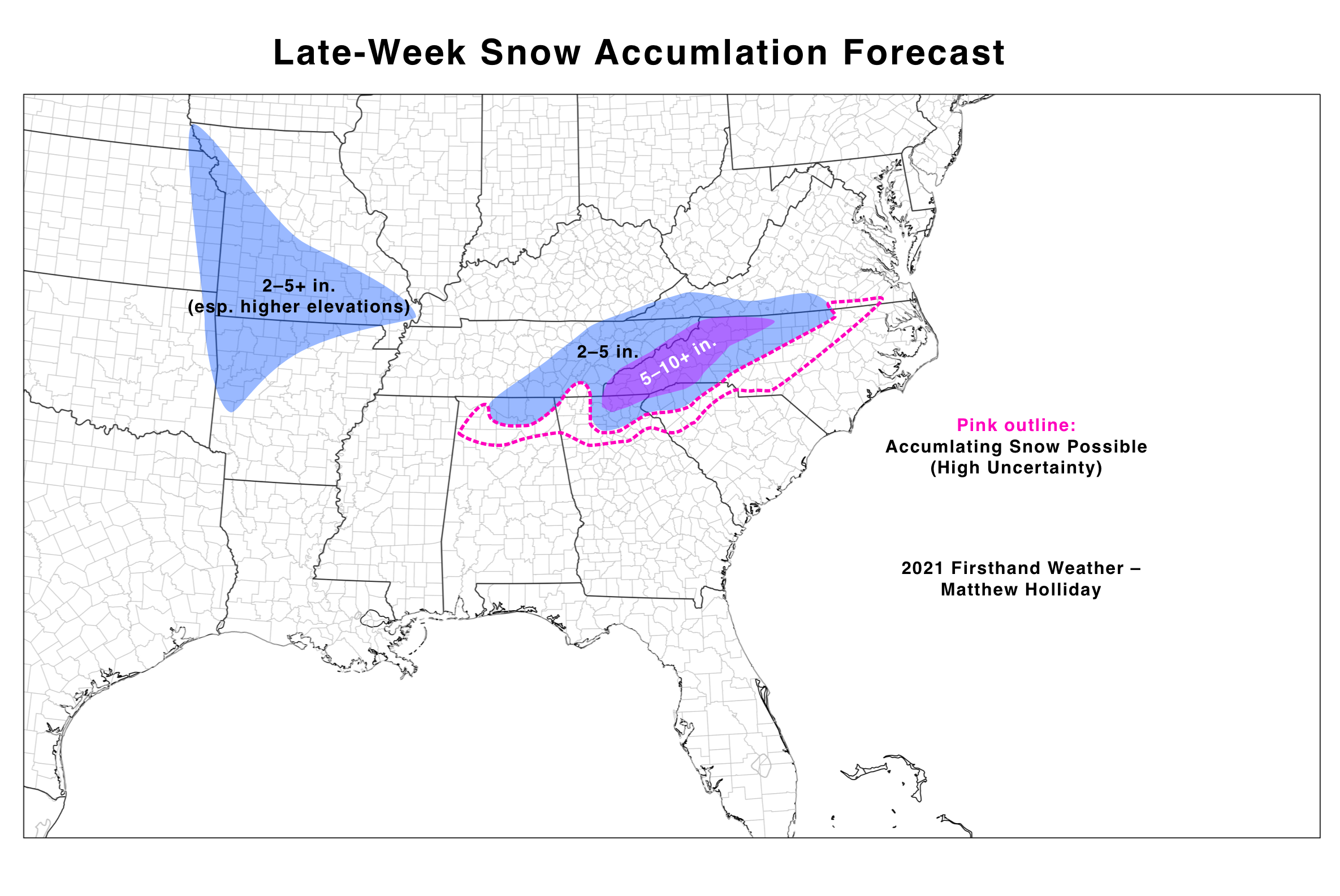
Snow accumulation forecast for late-week winter storm
Snow Accumulation Forecast (Attempt #1)
-
I included a 5–10+ inch accumulation zone in the mountains of Georgia, South Carolina, North Carolina, and Tennessee, where soil temperatures are already relatively cool and low-level temperatures should be sufficient for snow (or a rain to snow transition).
-
I expect noteworthy accumulations to fall across the Cumberland Plateau, far northern Alabama, northern Upstate South Carolina, and western central North Carolina. A transition of rain to snow will likely occur as the mid-level and surface low wraps around colder air.
-
Far southeastern Kentucky and lower Virginia could get accumulating snow; however, if the surface low jogs slightly south, most precipitation will remain south of the area.
-
I outlined a region in pink, where this storm system could potentially bring unexpected accumulating snowfall. I currently have included the northern metro of Atlanta in this zone. Again, strong forcing will need to offset the very marginal air mass in place. Otherwise, expect a cold rain.
-
I expect only a cold rain across the rest of the Southeast and Mid-South.
Please stayed tuned for subsequent forecasts on this potential winter storm. Don’t forget to download our Southern Snow app. Our app provides you with snow forecasts from both Firsthand Weather AND your local National Weather Service office. Check it out!