White Christmas Forecast 2020
Now that we’re less than 7 days from Christmas, our Southern Snow app will provide you a super-localized forecast on the upcoming snow potential this Christmas week. Our written forecast discussions, such as this one, should provide a nice ‘heads up’ that may or may not be currently reflected in the daily forecasts. You sort of get the best of both worlds if you have the app.
High probabilities
A strong shortwave will enter the Pacific Northwest on Tuesday and sweep across the Rockies on Tuesday and Wednesday. This system will add to existing snow cover across the Cascades, the northern Sierra Nevada region and most of the Rockies, ensuring a White Christmas.
Snow cover from last week’s nor’easter will begin rapidly melting on Christmas Eve and Christmas Day. However, areas that picked up feet of snow across the Mid-Atlantic and Northeast will still have snow cover from the event, even at lower elevations.
Moderate probabilities
The upper Midwest and the Great Lakes region will have several opportunities for snow in the coming days. A weaker system will pass through the area early this week, and a stronger storm system will set the stages for lake-effect snow on the backend on Christmas Eve and Day.
The same mid-week system has the potential to bring noteworthy snow accumulations to areas along and west of the Appalachians, along with western areas of New York.
Possible probabilities
One could make the argument that some areas included in the possible probabilities category should eventually get bumped up to moderate chances. I concur. As one shortwave swings across the Midwest and Great Lakes mid-week, another wave will dig southeastward into the Plains and mid/lower Mississippi Valley. As a result, a second surface low could develop farther south early Christmas Day, bringing snow chances as far south as eastern Tennessee and the northern Gulf coast states.
The air mass behind the advancing strong cold front will be very dry, so there remains much uncertainty on moisture availability. Nonetheless, snow-to-rain ratios will be high behind the front, so even a little moisture and lift would do the trick. Climatologically, these setups have a relatively high probability of being a bust for snow, especially farther south. However, if I see that short-range guidance supports higher totals, I’ll probably need to bump up probabilities to a moderate for some.
Before coming eastward, the same wave will have the potential to produce accumulations east of the Rockies across Colorado, Wyoming, and into parts of the Northern/Central Plains before Christmas Day. It’s quite likely some of those areas will get pushed into moderate probabilities in a subsequent update by Firsthand Weather.
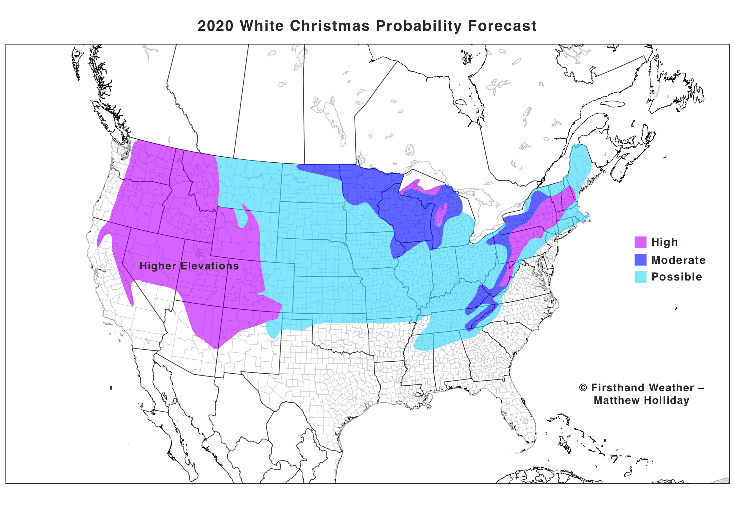
2020 White Christmas Forecast
Firsthand Weather Decals
We’re making Firsthand Weather decals available to our audience for $3. If you want one, make a comment on one of our social media pages, and we’ll reach out to you.