Tropical Depression may develop off the Southeast coast, making landfall in Georgia/South Carolina
The low pressure off the Southeast coast has continued to organize and strengthen over the past 24-hours despite moderate wind shear over the system. Further strengthening is possible over the next 24-hours as the system moves into an area of lesser wind shear and over the Gulf Stream.
Join the Firsthand Weather Supporter Group for exclusive weather content: https://www.facebook.com/becomesupporter/136842186352541/
The relaxed wind shear and the warm ocean waters of the Gulf Stream may be enough to allow the low pressure to acquire tropical characteristics. A Tropical Depression or Tropical Storm may develop Monday as the low approaches the Southeast Coast. The system has a 50% chance to develop into a Tropical Depression or Tropical Storm Monday.
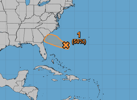
The system will make landfall late Monday somewhere along with Georgia or South Carolina coast. Regardless of development, the system will produce rough seas, storm surge rip currents, and beach erosion for the aforementioned areas. Along with these hazards, an uptick in rain chances, gusty winds, along with isolated tornadoes and waterspouts are possible for coastal Georgia and coastal South Carolinas. The rain chances will also spread inland into Georiga and South Carolina.
Right now the forecast calls for 1-2″ of rain in southeast Georgia and southern South Carolina over the next 48-hours, but these totals may need to be upped over the next few hours if this system continues to strengthen.
The wind forecast is low at this time due to the system not being tropical. The current forecast calls for wind gusts up to 30 mph for much of South Carolina, northern and eastern Georgia, and southeastern North Carolina late Monday into Tuesday. If the system continues to strengthen, the wind forecast will need to be upped.
This is a fluid forecast. Keep checking back for updates!