Eyes on tropical development off of the Southeast coast, the system is moving towards the coast
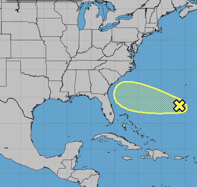
The National Hurricane Center is monitoring an area of showers and thunderstorms a couple hundred miles south of Bermuda. This area of showers and thunderstorms is forecast to slowly advance west, towards the East Coast, over the coming days and should begin to observe a slight lowering of pressure.
As the pressure begins to lower, which is a sign of strengthening or organization, the broad area of low pressure may begin to develop into a Tropical Depression or Tropical Storm. Right now, any development is forecast to be rather slow, and the odds of development are very low. The National Hurricane Center gives this system a 10% chance of development over the next 5 days.
A current look at the system (the area of clouds on the right side of the image) shows showers and thunderstorms have increased in coverage but organization is currently lacking and there is no real surface circulation with the system.
The system will move into an area of moderate shear (red area off the coast of the Carolinas) over the next day or two, which should mitigate development. Shear disrupts tropical systems and tends to prevent them from developing and/or strengthening.
The shear will gradually relax by mid-week (notice the red colors disappear near the Carolinas), which could allow for organization and strengthening to gradually occur.
Regardless of strengthening, the system will track west due to an upper-high north of the system. The system will track along the southern periphery of the upper-high. This will guide the system into the Southeast Coast from mid to late week. It is likely this wont be a Tropical Depression or Storm, but increased atmospheric moisture is possible, leading to showers and storms that could produce heavy rain for parts of the Carolinas and Southeast.
This will continue to be monitored so keep checking back for updates.