Heavy rain and storms leads to flash flooding this week in the South
Scattered to numerous storms are in the forecast for parts of the South and Southeast this as a cold front stalls then moves very slowly across the region. The cold front, paired with a few upper-level disturbances, will allow for several rounds of showers and storms across the region, leading to areas of excessive rainfall through mid-week.
The rain potential is concerning due to the slow moving nature of the cold front I) allowing numerous storms to move over the same areas, II) high amounts of atmospheric moisture allowing for heavy rainfall rates, and III) recent heavy rainfall across the region. The aforementioned variables will lead to a risk of flash flooding from Texas, east into Georgia.
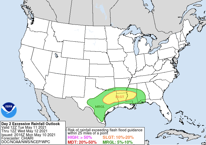
Tuesday’s flood risk extends from western Texas, through the Mid-South, into Alabama. Spot areas of flash flooding are possible for these areas. A higher flood risk exists from central Texas, into southern Arkansas, northern and central Louisiana, into central Mississippi. If you live in a low-lying, flood-prone area, make sure you’re aware of your surroundings and stay up-to-date with the latest forecast. Never cross a roadway covered by water.
Tuesday’s flood risk
The flood risk continues on Wednesday but shifts farther south and east. The flood risk will extend from coastal Texas, through central and southern Louisiana, into southern Mississippi, southern Alabama, the Florida Panhandle, and southwestern Georgia.
Wednesday’s flood risk
While the rainfall amounts don’t look overly impressive, due to the rate at which the rain will fall, paired with the saturated grounds, flash flooding will be realized for parts of the region. Widespread rain accumulations of 2-3″ will fall from central Texas, east into Louisiana, southern Arkansas, Mississippi, central and southern Alabama, and southern Georgia. Isolated amounts up to 6″ are possible.
Rainfall forecast Southern Plains
Rainfall forecast Mid-South and Southeast
Rain will begin across the Southern Plains and Mid-South early-Tuesday and continue through Wednesday. The rain threat will shift into the Southeast late-Tuesday and continue into early-Thursday. While the flood risk is lower for the Carolinas, a good soaking is in the forecast with many areas picking up close to 1″.