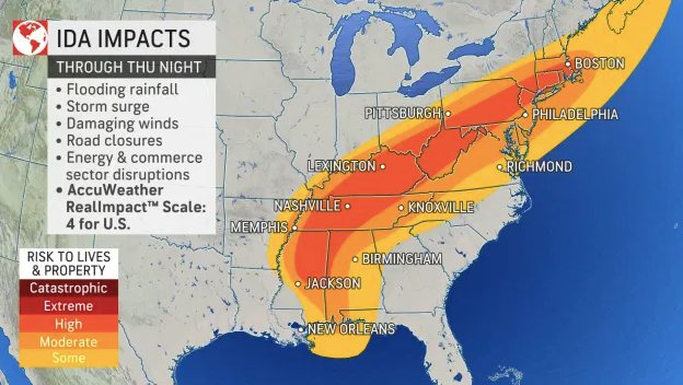
Ida’s impacts spread inland this week: heavy rain, flooding, and tornadoes possible
We are not finished with the impacts from Ida. Ida will continue to be felt over the coming days as it moves north, followed by a northeast movement. The current forecast calls for Ida to remain a tropical depression as it moves from the South into the Tennessee Valley and Mid-Atlantic from early to mid-week.
Ida forecast (courtesy Weather Nation)
The wind threat will decrease as Ida moves inland but the flood threat will increase. A swath of heavy rainfall is expected from the South into the Tennessee and Ohio Valleys from early to mid-week, followed by heavy rain moving into parts of the Carolinas, Mid-Atlantic, and Northeast later in the week. Several inches of rain are forecast.
3 to 6 inches will occur from Mississippi and Alabama, north into Tennessee and northern Georgia, Upstate South Carolina and the mountains of North Carolina, Kentuck, and Ohio, and the Mid-Atlantic. Isolated 8 inches cannot be ruled out. This is concerning, especially in Tennessee and North Carolina where recent catastrophic flooding has occurred.
Rainfall forecast (courtesy the Weather Channel)
The flood threat will shift from southwest to northeast Monday through Thursday. If you live in a flood-prone area, please be on high alert, and never cross a roadway covered by water.