Is the Southeast really going to get an ice storm in a week?
I want to take a moment to address the chatter about the possibility of an ice storm across parts of the Southeast next week. I’ll discuss how you should interpret model guidance, and why you shouldn’t take individual model runs verbatim. However, I’ll show you why the upcoming pattern favors wintry weather. But remember, providing specifics 7 to 10 days away from a potential event is beyond the capability of this science. Focus on the pattern instead!
I’ll give you a recent example of what not to do. Several of our followers have asked us about a post that has gone viral this evening. You always want to avoid focusing on individual model output a week in advance. If Atlanta received 1.5 inches of ice, that’d be catastrophic, but there are a lot of intricate details that could change this forecast many, many times between now and then. That’s why no one should ever make a post like this. It’s pseudo-science. I hope you view this more as a learning opportunity for our followers instead of a dig at someone’s credibility.
We’ve discussed on Firsthand Weather over these last few days (especially in our supporter group) why the pattern in a week or so could actually be promising for wintry precipitation across parts of the South. Of course, that’s assuming everything evolves as we’re expecting. We also noted that we had concerns about icing issues, which hasn’t changed.
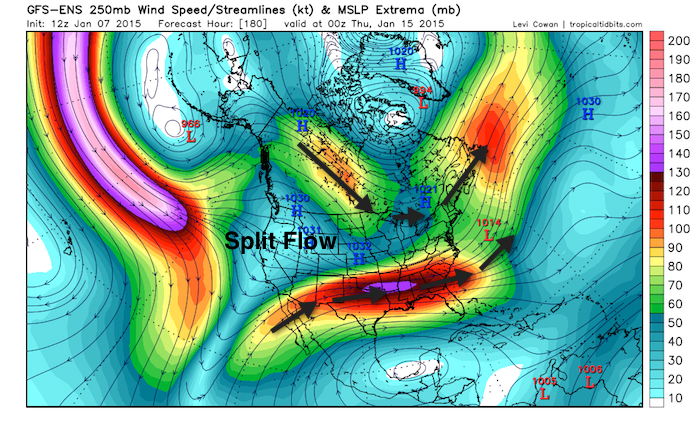
You may have heard us use the term ‘split-flow pattern.’ Sometimes, a ridge will build across the Pacific Northwest, which can also extend into British Columbia and Alaska. This type of pattern often allows colder, higher-latitude air to spill into the U.S. east of the Rockies. Of course, the amplitude of the ridge and its orientation can affect how far south the colder airmass makes it. That’s only one component of the pattern. The other component is an active sub-tropical jet stream that sets up to the south of the western ridge, which provides a pathway for storm systems to trek across the southern states (sometimes from the West Coast to the East Coast). If you check out projected winds at the jet stream level in the latest GFS, notice how the Pacific jet stream splits before reaching the West Coast. Again, the northern component of that split help drives colder air into lower latitudes, while the southern component of the split helps transport moisture across southern regions.
I want our followers to look at all of this from a probabilistic standpoint. A split-flow pattern simply increases the odds of wintry weather occurring across parts of the South. Remember in the first Dumb and Dumber movie when Mary Swanson told Lloyd Christmas that there was a one in million chance that she’d go out with him, he was ecstatic. There was a chance!! At this point, there’s a chance, and for some of you, the odds are definitely better than one in a million.
In the coming days, we’ll need to begin identifying any trends in the model guidance, which is the second step. The first step is establishing how the pattern might evolve, which tells us what to potentially look for in future model runs. We’ll soon begin pinpointing regions that will be at risk for wintry weather, and if it becomes apparent that an event will unfold, only then will we begin forecasting amounts. Regions that run along, east and even south of the Appalachians should especially pay attention to any trends. If surface high pressure does trek eastward into New England and a surface low does move across the Southeast, it’s not unreasonable to suggest that an icing event could occur as far south as parts of the Carolinas and even northeast Georgia. There still remains uncertainty about the availability of sufficiently cold air elsewhere across the Southeast (e.g. the northern Gulf coast states). However, this upcoming pattern does provide better odds for wintry precipitation across parts of the South, which hasn’t been the case for most Decembers over the last decade. But don’t forget, focus on the pattern and trends, and don’t expect specific details this soon. We promise we’ll keep you in the loop on Firsthand Weather.
Make sure you join our supporter group on Facebook if you haven’t already. Click here to join. I post details there (e.g. my recent post made on Tuesday evening) that I’m currently not comfortable sharing publicly. You often see a finished project on Firsthand Weather. In the supporter group, you get to see more of the process. Please consider joining!