Laura Could Rapidly Intensity Over The Gulf of Mexico As It Heads Toward Louisiana/Texas
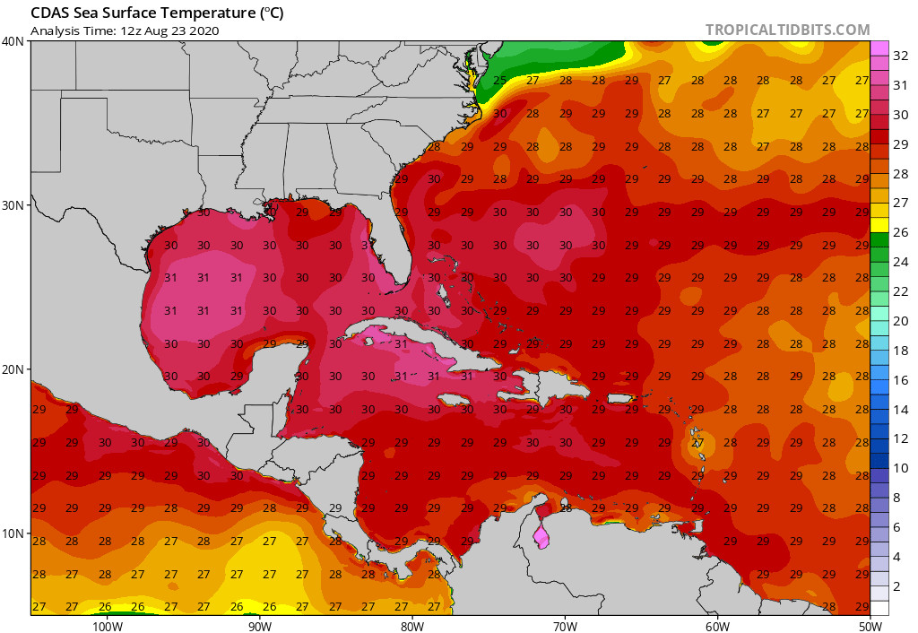
Laura has begun to develop deep convection (thunderstorms) over the past several hours as it skirts along the southeastern Cuba coastline. We expect Laura to mostly continue on a northwestward trajectory on Monday, and even though it’ll continue riding along the southern Cuban coastline for another 24 hours or so, part of the storm will remain over open water the entire time. Sea surface temperatures south of Cuba run in the 30-31°C (~86-88°F) range, which are more than sufficient to allow Laura to maintain its current intensity or even strengthen in the short-term, despite its interaction with the mountainous terrain of Cuba.
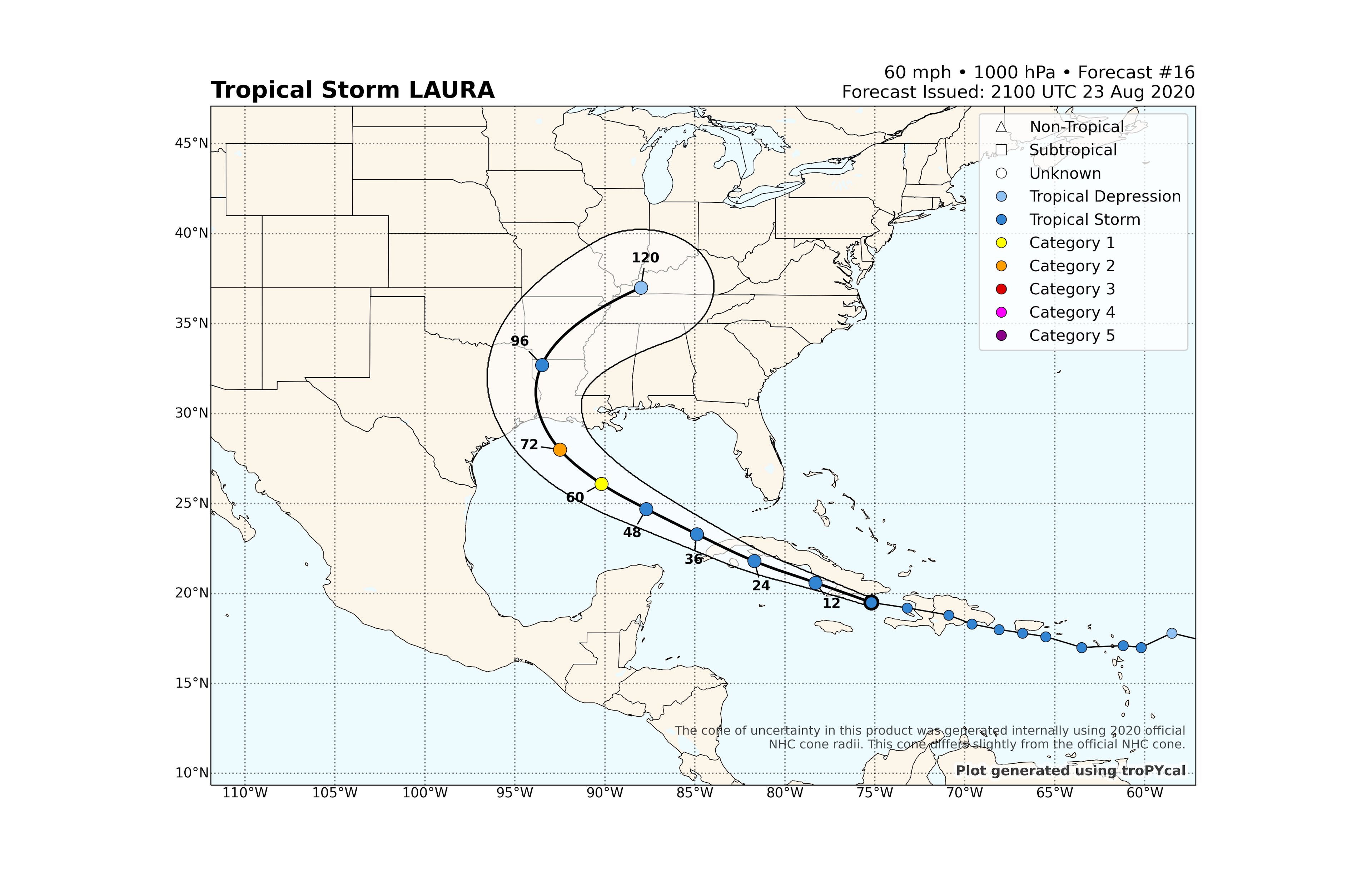
Most model guidance a couple days ago had Laura’s center moving through Cuba, but the storm has had a tendency to move a little farther south than most model projections. When a tropical cyclone moves parallel to a chain of landmasses, especially ones that have mountainous terrain, a few dozen mile difference in track can make a dramatic difference in current intensity, subsequent intensity change, and even track. As Laura emerges over the Gulf of Mexico by early Tuesday, we anticipate that the system will be more intact than it otherwise would have been. Thus, it should take less time for Laura to capitalize on the anomalously warm waters beneath it.
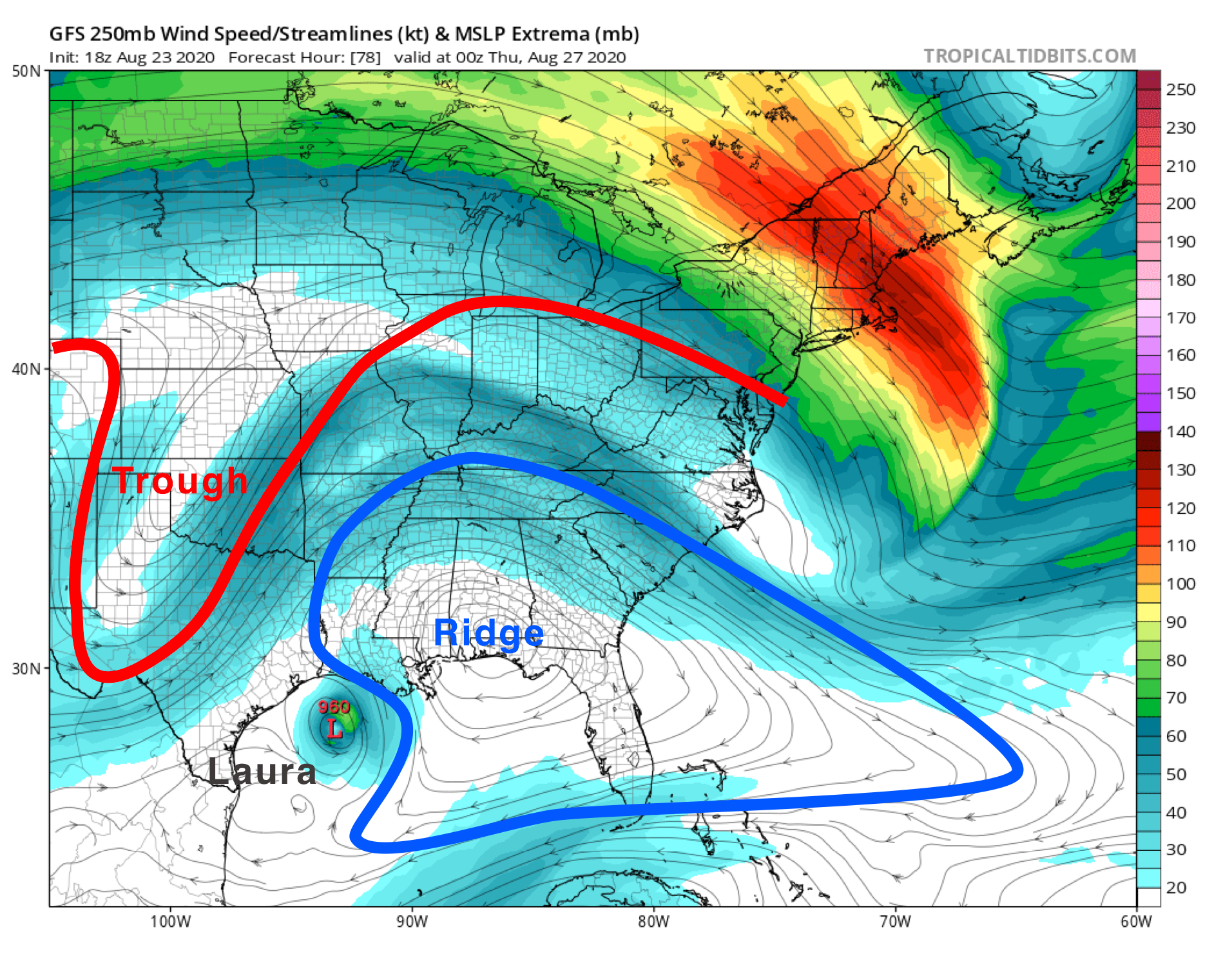
A strong, deep-layer high pressure system currently sits just off the Southeast coast, which currently places Laura to the south of the feature. As Laura treks northwestward, this ridge will continue expanding westward, which will prevent the storm from simply turning northward toward Florida once departing Cuba. Hurricane Marco will actually help strengthen the ridge as well. Tropical cyclones, like Laura and Marco, extract heat energy from the underlying ocean via evaporation. This process helps further moisten the air above, and that heat from the ocean gets released into the atmosphere when clouds and deep thunderstorms develop. Thanks to Marco assisting in the strengthening and westward expansion of the ridge, Laura will continue on a northwestward track longer, which 1) will give Laura more time over the warn Gulf of Mexico and 2) will put Louisiana/Texas at a higher risk for a Laura landfall.
Marco will stay weaker due to a mid-to-upper level trough that currently extends southwestward into eastern Texas/northeastern Mexico and over the Gulf of Mexico. Thus, Marco will encounter vertical wind shear, keeping its intensity at bay. However, the trough will retrograde westward by the time Laura makes it into the Gulf of Mexico, which means that Laura should encounter considerably less wind shear.

We expect Laura to rapidly intensify over the Tuesday to Wednesday timeframe, which corresponds to an intensity increase of at least 35 mph (30 knots) over a 24-hour period. The National Hurricane Center currently predicts that Laura will reach upper-end category 2 status in 72 hours. However, it’s possible that most model guidance is underestimating how much strengthening will occur, especially if Laura’s low/mid-level center manages to stay mostly off the Cuban coast over the next 24 hours. Also, Laura is expected to move at a relatively fast pace over the Gulf of Mexico, which will decrease the odds that upwelling of cooler sub-surface ocean waters will hinder Laura’s intensification. Thus, it’s plausible that Laura could become a category 3+ storm.
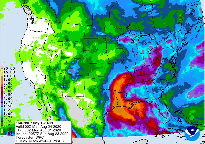
With all of this said, it’s very important to understand that severe winds are not the only hazard associated with hurricanes. While the strongest winds remain closest to the storm center, flooding often becomes a much more widespread risk, well away from the center. As of now, the heaviest rainfall will fall across much of the Mid-South and potentially extend into eastern parts of the Southern Plains. In the projected 7-day rainfall totals, the axis of heaviest rainfall totals curves around the periphery of the westward-expanding ridge, which corresponds with Laura’s projected path.
We’ll reassess the forecast again on Monday to determine the effect that Laura’s interaction with Cuba will have on its intensification in the Gulf of Mexico. Please understand that the forecast will likely change, especially over the next 24 hours, but afterwards, forecast confidence will hopefully increase.