Nasty Ice Storm to Unfold Across Mid-South, Southeast, and Mid-Atlantic
A strong shortwave approaching the Southern Plains has already resulted in a precipitation shield developing across much of Oklahoma and upper Texas. As the wave treks across the two states overnight, precipitation will fill in across the eastern half of Texas tonight before doing the same across Arkansas, Missouri, and Louisiana overnight into Wednesday morning. The Arctic air mass remains well entrenched over much of the Southern Plains and Mid-South. Surface high pressure over the Ohio Valley will begin departing eastward of Wednesday, but with recent snow/sleet cover, plenty of cold air will remain in place to help pull off another powerful winter storm across recently impacted areas.
In this article, I will focus primarily on the ice storm threat with the coming system. A mixture of freezing rain and sleet will likely lead to scattered to widespread power outages across parts of eastern Texas, lower Arkansas, Louisiana, and Mississippi on Wednesday/Wednesday night and across parts of North Carolina and the Virginias on Thursday.
Southern Plains & Mid-South Ice Storm Impacts and Timeline
Temperatures will continue to plummet overnight tonight across the Plains and Mid-South. Widespread 20s already overspread the region of interest, and many of those areas will drop into the teens overnight. Precipitation will reach Arkansas, far northern Louisiana, and northwestern Mississippi early enough Wednesday to fall mainly as snow at first. An associated surface low will skirt along the southeast Texas and then across the Louisiana coast on Wednesday. This low will transport warmer air overtop colder air at the surface. This warm nose will lead to a nasty freezing rain moving across eastern Texas, the northern two-thirds of Louisiana, lower Arkansas, and western/central/northern parts of Mississippi.
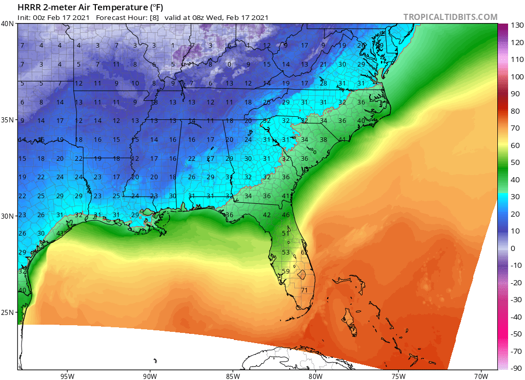
Projected temperatures by overnight early Wednesday morning
Due to strong, low-level warm air advection, the latest NAM guidance results in freezing rain/sleet transitioning to a cold rain more quickly across much of Louisiana and Mississippi later on Wednesday. Warm advection will partially be offset by melting on Wednesday, since the ice-to-liquid phase change is a cooling process. Plus, dry air in the low levels will result in evaporational cooling keeping colder air in place for longer. For these reasons, I favor the colder HRRR model guidance, which has an ice storm impacting areas farther to the south. The latest HREF ice accretion projections for Wednesday and Wednesday night provides some idea as to where the heaviest freezing rain accumulations will occur. A large swath of 0.5-1+ inch freezing rain accumulations could fall, resulting in widespread power outages. Due to the self-limiting nature of ice storms, freezing rain accumulations these high can be challenging to reach. However, surfaces already well below freezing will allow accumulations to occur immediately. To provide some perspective, amounts as little as 0.05-0.1 inches can cause major issues on roads, especially on bridges and overpasses.
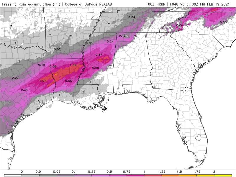
HRRR Ice Accumulation Projections over the next 48 Hours
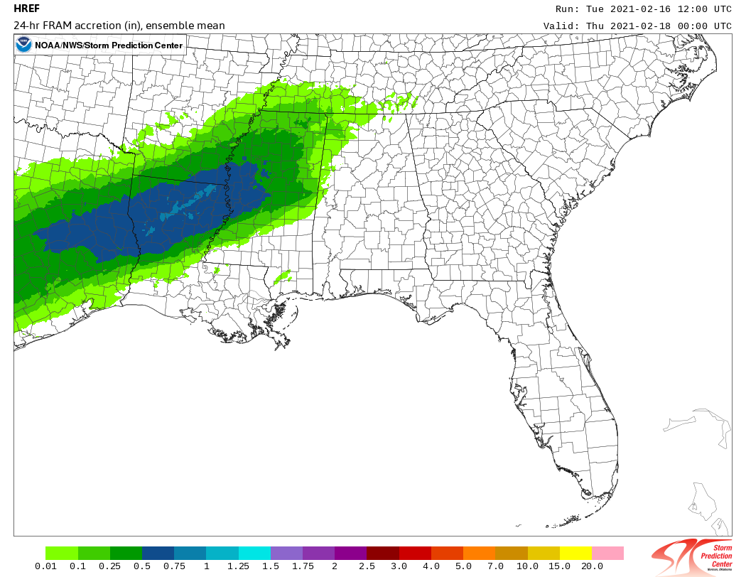
HREF Ensemble Projections from Tuesday evening into Wednesday evening
Carolina and Mid-Atlantic Ice Storm Impacts and Timeline
The surface high across the Ohio Valley on Wednesday will shift into New England late Wednesday into Thursday. Surface ridging will build down the east side of the Appalachians, setting up a cold air damming setup. As mid-level ridging along the East Coast amplifies on Thursday, the surface low along the Gulf coast will take on a northeastward trajectory. As the feature moves across central Georgia and South Carolina during the day, rain will overspread much of the Southeast. However, enough cold air at the surface will allow a major ice storm to unfold across western/central/northern parts of North Carolina, much of Virginia, southeastern West Virginia, and into the Delmarva peninsula.
Strong warm air advection in the low levels will eventually result in a transition from sleet and/or freezing rain to a cold rain across upper South Carolina and lower parts of North Carolina. The timing on this transition will determine ice totals in that region. The latest HRRR guidance doesn’t depict any significant totals since it has sleet transitioning directly to rain, but HREF ensembles indicate a more prolonged period of freezing rain down to the North Carolina/South Carolina border. Ice totals in northern Virginia into the Delmarva peninsula should receive lower ice totals relative to areas to the south due to more snow in the beginning. For areas in between, the ice storm could bring totals reaching or even exceeding 0.25-0.5 inches.
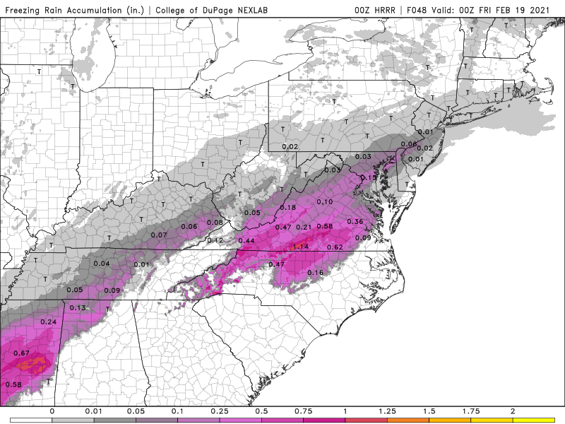
HRRR Ice Accumulation Projections over the next 48 Hours
HREF Ensemble Projections from Wednesday morning into Thursday morning