Strong tornadoes are possible in the South today
12:20 PM CST UPDATE
A Tornado Watch has been issued for parts of Louisiana, Arkansas, Mississippi, and Tennessee until 7:00 PM CST.
A tornado watch has been issued for parts of Arkansas, Louisiana, Mississippi and Tennessee until 7 PM CST pic.twitter.com/cmfaC7PGot
— NWS Tornado (@NWStornado) December 29, 2021
AFTERNOON UPDATE
The enhanced severe risk has been expanded into northwestern Georgia. Also, a couple of strong, damaging tornadoes are possible per the Storm Prediction Center.
ENHANCED RISK TODAY: A few tornadoes, one or two of which could be strong, damaging gusts, and isolated large hail is expected from parts of the Lower Mississippi Valley into the Tennessee Valley and the southern Appalachians vicinity through tonight #ALwx #TNwx #GAwx #ARwx #MSwx pic.twitter.com/6wyIHgsMfv
— RadarOmega (@RadarOmega) December 29, 2021
PREVIOUS INFORMATION
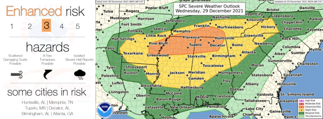
A hyper-active weather day is expected across the South this afternoon and evening. Severe storms are expected to develop west of the Mississippi River earlier in the day advancing east throughout later parts of the day. A severe threat will continue into the nighttime hours. An enhanced risk (level 3 of 5) is in place for parts of eastern Arkansas, northern Mississippi, southern Tennessee, and northern Alabama. A slight risk (level 2 of 5) and marginal risk (level 1 of 5) surround the enhanced risk area.
12/29 710 AM CST: The Enhanced Risk has been expanded eastward into more of northern AL. Tornadoes, damaging winds, and isolated large hail still appear possible from parts of the lower MS Valley into the TN Valley and southern Appalachians, mainly this afternoon through tonight. pic.twitter.com/rCR3wZZzss
— NWS Storm Prediction Center (@NWSSPC) December 29, 2021
Within the enhanced risk (orange), this is where the highest chance for severe storms and the greatest coverage of severe storms is expected. This is also where the highest tornado threat exists today into tonight. Other severe hazards include damaging winds and large hail. There is also a tornado, wind, and hail threat for the slight (yellow) and marginal (dark green) severe risk areas.
Make sure you’re staying weather-aware throughout the day. It’s important to have a few reliable sources to receive weather warnings from and have a plan in place and know where to go if a warning is issued for your area.