Significant severe weather outbreak possible Saturday
Forecast Discussion: A strong shortwave is currently sweeping across the Four Corners region, which has induced the development of a surface low pressure system over the southeast Colorado/northeast New Mexico border. As the strong shortwave closes off into a mid-level low pressure system, the surface low will move into southwestern Kansas over the next few hours. A frontal boundary is currently stalled out across central Missouri, lower Illinois/Indiana and along the Ohio River in Ohio/Kentucky. A very moist environment exists south of the frontal boundary at and near the surface. As the surface low treks across Kansas tonight and tomorrow morning and into Missouri/Iowa late Saturday afternoon, the stalled front will begin moving northward as a warm front, replacing the dry airmass to its north with moisture-laden air. Throughout the day Saturday, surface dew points will increase across southeast Iowa and over the remainder of Illinois, Indiana, and Ohio.
Isentropic lift occurs when warmer air pushes up and over a colder airmass, which can generate precipitation. Isentropic lift, along with embedded weaker shortwaves, will continue to generate rainfall along and north of the soon-to-be warm front tonight into tomorrow morning across much of the lower Midwest. If you take a look at the Storm Prediction Center’s (SPC) severe weather risk area for Saturday, they have an enhanced and moderate risks extending from far northeast Missouri and southeast Iowa into northern/central Illinois, and northwestern Indiana. Please be aware that conditions in the morning (6-8am CT) may not feel like a severe weather day across the enhanced/moderate risk areas. Since the warm front will have not moved through much of the region at this point, temperatures will be somewhat chilly, especially with the rain falling. However, as the warm front surges northward, low-level moisture (humidity levels) will increase rapidly into the afternoon hours.
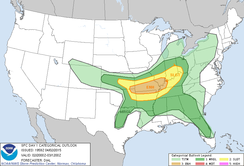
The surface low will move into western Iowa by mid-afternoon, strengthening further as it moves into the region. The region positioned just east of the surface low, ahead of the cold front, and south of the warm front will have the greatest risk of dangerous severe weather, as outlined in the SPC forecast. Rainy weather in the morning hours should move out quickly enough to allow for sufficient daytime heating at the surface. As the mid-level low approaches from the west, mid-level temperatures will cool, which will increase instability within the atmosphere. Surface-based instability allows air parcels (bubbles of air) near the surface and within the low levels of the atmosphere to begin rising. Surface heating and the addition of moisture makes those low-level air parcels buoyant. By cooling the mid-levels of the atmosphere, this ensures that the rising air parcels will remain warmer than the surrounding environment, allowing them to keep rising. This strong rising motion in the atmosphere on Saturday will result in deep thunderstorms developing across the risk zone, which will cause an increased risk for very large hail.
Tornado Risk: The enhanced and moderate risks also have been issued due to the tornado risk tomorrow. Within the treat zone, winds will flow from the southeast at the surface but will veer to the southwest with increasing height. We call this vertical wind shear. The position of the surface low relative to the mid-level low and shortwave will cause this turning of the winds with height. Given higher instability and vertical wind shear, tornadoes, some of which could be EF-2 or stronger, are expected. In fact, long-track tornadoes are possible. Keep in mind that the tornado risk extends southward into the Mississippi Valley ahead of the cold front as well; however, the tornado probabilities across that region will stay comparatively lower.
Chicago Tornado/Hail Risk: You might notice that the SPC only has Chicago under a slight risk; however, residents should watch the forecast closely tomorrow afternoon into the evening. The 18z NAM model is slower with moisture return across the Chicago area. By 5pm CT, the model projects dew points to only be in the mid to upper 40s. To the contrary, the HRRR model guidance has consistently projected dew points to be in the upper 50s or 60°F around the same time in downtown Chicago and well into the 60s in the western and southern metro. Timing matters a lot. If the low levels moisten sooner in Chicago, this could increase the tornado risk across the city, especially in the western and southern metro. Which model do we pick? That’s a tough question, especially when they’re trying to iron out intricate details. From what I can tell, the NAM model keeps conditions a bit cloudier across northern Illinois into the afternoon and even has storms moving through a little earlier than the HRRR model does. On the other hand, the HRRR has more daytime heating across the area, which would likely allow the warm front to advance northward more quickly. In effect, this would give developing and passing storms a much more unstable environment to work with. Honestly, I wouldn’t be surprised if the SPC bumps up the risk across areas closer to Chicago in their next update.
Please continue to monitor the situation closely throughout the day tomorrow. These forecasts are never perfect, which means that you should expect some forecast modifications tonight and tomorrow morning.