Southeast White Christmas? Part 1
We made a post the other day asking our followers when they had experienced their last White Christmas. Quite a few said never. A few others said back in 2010. Since many of our readers live in the Southeast, those responses weren’t all that surprising. Climatologically, having snow on the ground at some point on Christmas Day in the Southeast is exceptionally rare. Though, not impossible. . .
In the coming days, we’re going to discuss those years that the Southeast had a White Christmas. They may be few and far between, but there’s value in revisiting the conditions and overall pattern that brought those rare snowy Christmases.
In this article, we will take a peek at how the pattern will likely evolve from now through Christmas Day. The overall pattern will remain quite progressive. Meaning, most regions of the U.S. will not remain under the influence of troughing or ridging for more than a few days at a time, if that. Unfortunately, such a setup favors lots of swings in temperatures.
For the first time in a while, temperatures MAY actually feel like Christmas on Christmas Day in the Southeast (give or take a day). Most model guidance agrees that a longwave trough will develop across the eastern half of the U.S., as ridging amplifies across western Canada and eastern Alaska. This pattern configuration favors anomalous warmth along the West Coast and into the Southwest. An anomalously cold air mass will sweep across most locations along and east of the Rockies. Even Florida could get in on this chilly air mass!
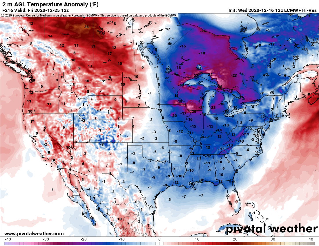
Projected departure from average temperatures Christmas Day morning
Most reading this post are already wondering, will there be any precipitation to go along with that brief shot of cold air in the Southeast? Maybe. The models indicate that a shortwave could become detached from the main flow and close off into a mid-level low as it approaches southern California and Baja California sometime next week. It would eventually get swept eastward by the southern stream. But features like these can meander for a while or even retrograde westward before getting reabsorbed back into the main flow. If the cold air intrusion is a strong as modeled, there could be about a two-day window, probably a day or two after Christmas, that any passing southern stream system could produce wintry weather for parts of the Southeast.
Taking a look at projected 500mb geopotential height anomalies from the latest European model, it already has the longwave trough lifting northeastward by the 26th. At the same time, the closed low quickly moves eastward across Texas/northern Mexico. Residual cold air may hang around for a day or two tops, thanks to a departing surface high. This closed low, or any southern stream feature for that matter, would need to encroach upon the Mid-South and Southeast just as the long-wave trough begins lifting out.
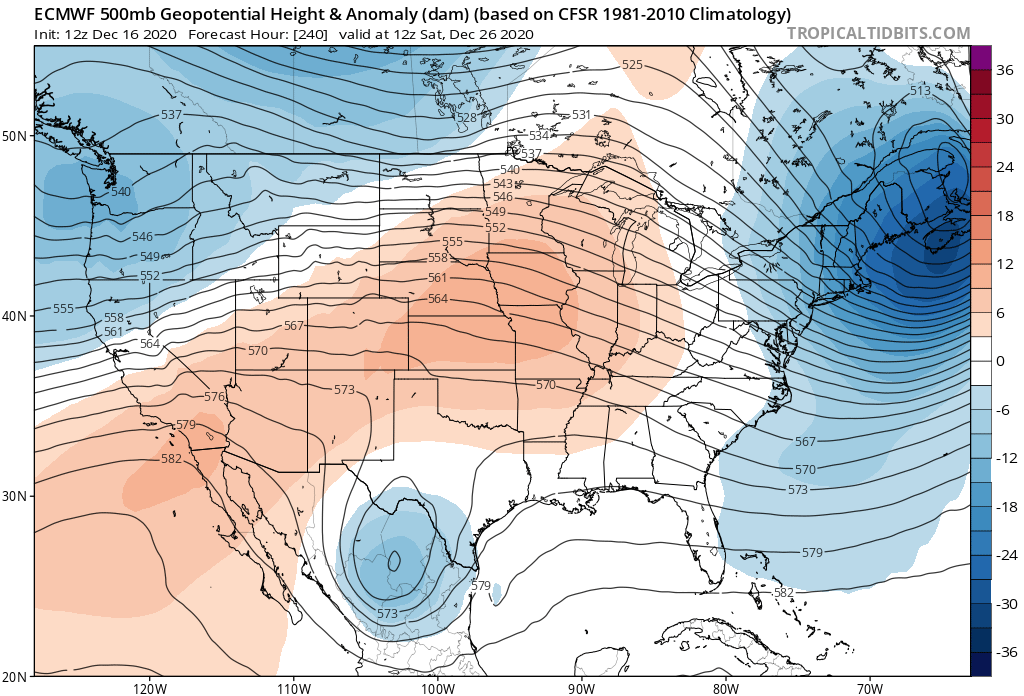
Longwave trough lifts out the day after Christmas
If I were a betting man, I wouldn’t put anything down on a White Christmas happening across the Southeast at this time. Yes, there could be a very brief window for some action right after Christmas Day, but that window appears to be short. I’d certainly recommend not getting too hung up on model guidance in the coming days. Large inconsistencies may exist in how models handle any closed low that develops. But hey, a small chance is always something to watch!
Make sure you download our new mobile app that’s dedicated to providing you with detailed snow forecasts. Firsthand Weather recently launched a new mobile app called Southern Snow for iOS devices, which gives you a snow forecast for anywhere in the U.S! If snow starts showing up in the forecast, Southern Snow will let you know.
Be sure to join us on the Firsthand Weather this Saturday at 2pm ET to get our official White Christmas forecast for the entire U.S.

Find out if you’ll have a White Christmas 2020 this Saturday on Firsthand Weather
The featured image used in this post is courtesy of Jennifer Kyzer, who captured a great shot of an early season snowstorm in SC in 2014.