Two-Day Severe Weather Event Including A Tornado Risk
Saturday-Early Sunday Morning: A strong shortwave system currently located over the Four Corners region has contributed to the development of a surface low pressure system over Mexico. As the shortwave advances eastward, the surface low will move northeastward across Texas tomorrow. By mid-afternoon, the low should be east of Dallas, TX, and by the evening, the system will begin moving across Louisiana/Arkansas. Widespread moderate rainfall will accompany this low across western Texas and across most of Oklahoma, but the primary concern for a potentially significant severe weather event is farther east into eastern Texas, northern Louisiana, southern Arkansas, and west-central Mississippi. Later into Saturday evening and early Sunday morning, the severe weather threat should continue across central-eastern Mississippi.
Aside from the light to moderate rainfall moving across northeast Louisiana and west-central Mississippi this evening, conditions across much of the Mid-South are quite pleasant. A frontal boundary associated with the previous storm system that dumped high snowfall amounts across the Plains and Upper Midwest is currently draped across the lower Mid-South. Since the frontal boundary never really had the opportunity to move well off the Gulf Coast, it won’t take much time for the low-level atmosphere to moisten as the surface low advances eastward over Texas. Dew points are only in the 40s and 50s across eastern Texas, northern Louisiana, and southern Arkansas this evening, but southerly/southeasterly winds will help bring dew points back into the upper 60s and 70s by tomorrow afternoon. Sufficient low-level moisture is a necessary ingredient for severe weather to occur.
Projected dew points on Saturday afternoon
Sometimes, morning thunderstorms and rainfall can help limit a severe weather risk if the atmosphere does not have adequate time to recover and become unstable. However, this should not be an issue tomorrow. Most of the widespread rainfall will remain mainly west of the Midsouth, and if morning activity develops across the region, it should remain scattered enough that plenty of daytime heating will still occur. Since the mid-level environmental temperatures will be quite cold (something that will actually contribute to more instability), temperatures around 70°F should be sufficient for moderate instability.
Projected radar for Saturday afternoon
Given sufficient instability and favorable wind shear profiles, a tornado risk exists across eastern Texas, northern Louisiana, southern Arkansas, and west-central Mississippi. Some tornadoes could be strong. Additionally, large hail and damaging winds will cause issues. The Storm Prediction Center has included a moderate and enhanced risk across those areas. If you are the risk zone, please plan accordingly, and ensure that you have a place to take shelter if a tornado hits your hometown.
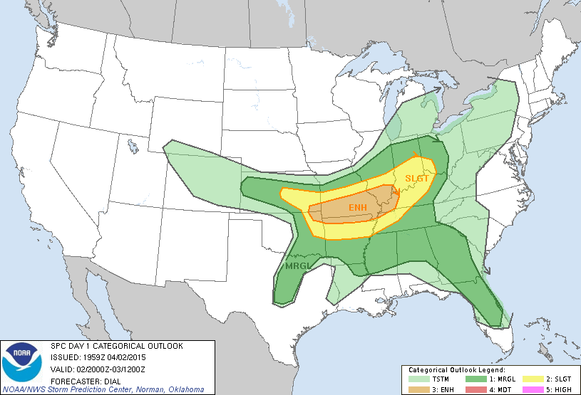
Saturday severe weather outlook from the SPC
Sunday-Sunday Evening: The surface low will continue advancing northeastward on Sunday and eventually move across the Ohio Valley. Given this track, a broad and elongated severe weather risk will exist across a large part of the Southeast and extend into the lower Ohio Valley. The Storm Prediction Center has placed an enhanced severe weather risk from Alabama and Georgia northward into southern Ohio. A squall line will eventually develop and move eastward later Sunday or early Monday morning just ahead of an advancing cold front. Though the squall line will primarily pose a damaging wind risk with isolated tornadoes, the bigger tornado threat will exist ahead of the squall line during the day on Sunday, where thunderstorms could be more discrete. Comparatively, the tornado threat may not be as high as on Saturday; however, sufficient instability and wind shear should favor the development of tornadoes across parts of the slight and enhanced regions on Sunday. I will provide a follow-up update for the Southeast tomorrow evening. After monitoring how everything evolves tomorrow and tomorrow night, I expect I will have to make some modifications on the magnitude of the Sunday tornado risk. As suggested above, please have a plan in place.
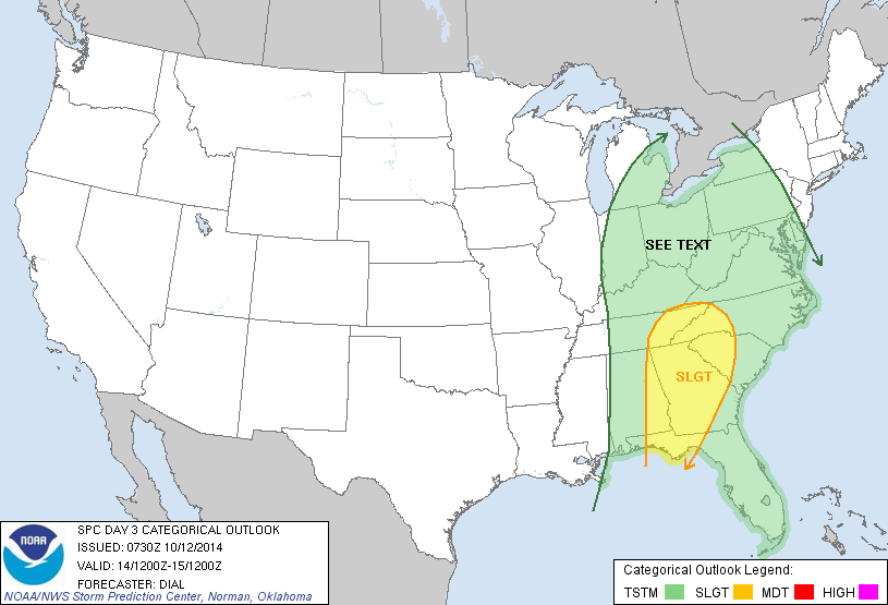
Sunday severe weather outlook from the SPC
Tornado sheltering guidelines recommended by FEMA
-Meteorologist Matthew Holliday