Tropical Troubles: Texas or Florida? How Strong?
The North Atlantic is quickly becoming active and confidence is growing that we may see a tropical system in the Gulf of Mexico by early next week. Numerical guidance has supported this idea over the past several runs and the National Hurricane Center (NHC) is keeping a close eye on this evolving scenario. The NHC has given an area of disturbed weather (over the western Caribbean) a 60% chance of development into a tropical cyclone over the next five days and a 10% chance of development within 48 hours (as the system crosses the Yucatan Peninsula and enters the southern Gulf of Mexico by Monday).

Western Caribbean/southern Gulf of Mexico being monitored by the NHC
What happens early next week? Why?
Numerical guidance parallels one another through the weekend, but by early next week the guidance diverges and uncertainty becomes high. This is where two possible scenarios evolve once the low establishes itself in the southern Gulf of Mexico: (I) the low is shunted near-due-westward towards the coast of Mexico/southern Texas, or (II) the low moves north-northeastward towards the coast of Alabama/Florida. The track of the low is heavily dependent upon the position of the mid-level ridge across the southwestern United States (that may build eastward), the strength and position of the Bermuda High, and the evolution (amplification or deamplification) of the trough digging across the eastern United States next week.
Mexico/Texas scenario:
The European model is showing the low pressure developing in the southern Gulf of Mexico by early next week (Monday) and moving towards the west or west-northwest. This particular scenario is due to the the trough not being as elongated towards the northern Gulf, which does not create a weakness along the southeastern coast. The European actually shows the mid-level ridge across the southwestern United States building eastward across the northern Gulf of Mexico. This would act as a barrier (protecting Alabama and Florida) meaning the low would move west to west-northwest. This path would cause impacts along the coast of Mexico and southern Texas (by Wednesday). If this scenario came to fruition, deep moisture moving into southern Texas would cause heavy rain, rough seas along the coast, and the potential of strong winds (depending on the strength of the system). It should be noted: the European is weaker with the low than the GFS-Parallel and Canadian due to adverse conditions (dry air and a potential Eastern Pacific system trying to develop) west of the system. Numerical guidance strength this early in the game should be taken with a grain of salt, however.

European 500mb map (Tuesday morning)
Alabama/Florida scenario:
The GFS-Parallel and Canadian show the low pressure moving towards the north-northeast as it approaches the coast of Alabama/Florida. (This guidance actually indicates a landfall near Panama City, Florida.) This particular scenario the GFS-Parallel and Canadian are painting is due to the the trough digging into the eastern United States remaining elongating, which creates a weakness along the southeastern United States. This also prevents the mid-level ridge across the southwestern United States from building eastward; creating a highway between southwestern ridge and Bermuda, which would steer the system into Florida by Tuesday night/Wednesday. This would mean the southeast (Alabama, Florida, Georgia, and South Carolina) would be impacted by the system; likely causing heavy rain, rough seas along the coast, and the potential of strong winds.

GFS-Parallel 500mb map (Tuesday morning)
A stalled frontal boundary across the northern Gulf would enhanced the heavy rain threat if this scenario came to fruition. It should be noted the GFS-Parallel and Canadian are much deeper with the low as it approaches the southeast (likely a tropical storm), but numerical guidance strength this early in the game should be taken with a grain of salt.

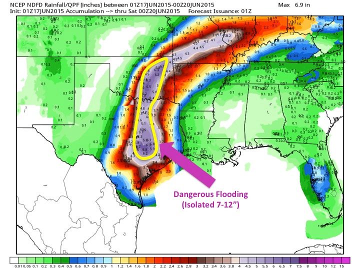
GFS-Parallel potential rainfall map (weekend through mid-week)
What should you do and confidence level:
While there are uncertainties in the exact evolution and movement of this system, we will gain more insight over the weekend into early next week. Confidence is moderately-high in a surface low developing in the southern Gulf of Mexico by Sunday evening/Monday. The confidence level becomes much lower when evaluating the eventual track and strength of the low. If you live anywhere along the Gulf Coast (Florida to Texas), make sure you stay abreast to this fluid forecast. Keep checking back for updates, and it would be wise to begin your tropical season preparations. Even if this system does not impact you, it is hurricane season, so it’s best to have a plan this time of the year!
Which scenario is most likely: Texas impact or Florida impact? And, how strong?
Please note, this is my opinion and updates will be needed once the low develops in the southern Gulf of Mexico. I believe the European guidance is most realistic at this point, which would cause a more westward track. However, I want to reiterate that track confidence is low. Those of you in Florida need to stay alert, too. A concern of mine is the European has shown a tendency as of late to over amplify the ridges across the south. This is something I will keep a close eye on.
If this low evolves in the southern Gulf of Mexico and deepens as it begins its movement (either westward or northward), I currently think this system will not get too strong. A low-to-mid-end strength tropical storm is most probable. SST are warm, there is relatively moist environmental conditions (outside of the coast of Mexico), the shear is pretty high. This shear will likely keep the system from getting too strong. With that said, just because the system may remain weak (wind-wise), flooding rain may be a huge concern.

GFS-Parallel environmental wind shear map (Tuesday morning)
An update will be provided tomorrow!