Awakening Atlantic?
The Atlantic Hurricane Season has been off to a sleepy start (luckily) but it appears things could be changing with an 'awakening' Atlantic. The National Hurricane Center (NHC) has identified four areas that have a chance to develop into tropical cyclones over the coming days.
First area: Central Tropical Atlantic (high chance for development)
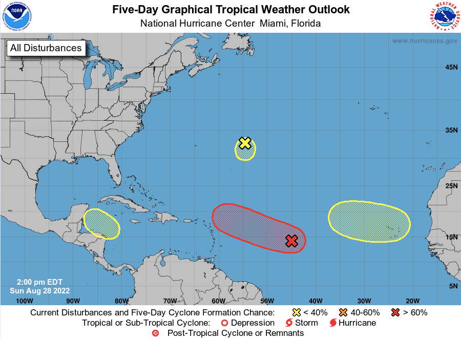
An unorganized area of showers and storms associated with a broad area of low pressure is expected to slowly start to organize and strengthen this week, potentially developing into a Tropical Depression or Tropical Storm. The NHC gives this system a 40% chance to develop over the next 48 hours and a 70% chance to develop over the next five days. This system will move WNW toward the NE Leeward Islands by the end of the week. There's a lot of uncertainty with the eventual track of this system beyond the work week, but the Greater Antilles, Bahamas, and the Southeast U.S. should keep an eye on the forecast for this system for the weekend and following week as it encounters an environment that could support continued gradual sustainability of intensity.
Second area: Northwestern Caribbean Sea (low chance for development)
A tropical wave/trough of low pressure could start to see an uptick in thunderstorm activity as it moves into a semi-favorable area for development. While the organization process looks to be slow, the NHC gives this system a 20% chance to develop over the next five days as it moves WNW toward the Yucatan Peninsula by the middle of the work week. This system could move toward Central America/southern Mexico or the southern Bay of Campeche by late week so all interests in the Gulf should keep an eye on this system despite the current low chances for development.
Third area: Central Atlantic (low chance for development)
Another system that's several hundred miles east of Bermuda has a low chance of about 10% developing into a tropical cyclone over the next 48 hours to five days per the NHC. This area of low pressure is in an environment that's not conducive for development as strong wind shear continues to chip away at firing thunderstorms. The system will slowly meander toward the south this work week and should gradually dissipate by the end of the week.
Fourth area: Eastern Atlantic (low chance for development)
A tropical wave expected to move into a favorable area for development this time of the year will move off the West Coast of Africa into the Eastern Atlantic. This wave has a chance to develop and should be monitored closely as it moves WNW over the days/week to come. The NHC gives it a 20% chance to develop over the next five days. This will likely gradually increase, all interests in the Caribbean and despite the uncertainty in the forecast and potential eventual track, the Southeast U.S. should keep a close eye on the forecast of this system over the days to come.
It's been several weeks since the last Atlantic Tropical Storm, and while it's been a quiet start to the 2022 Atlantic Hurricane Season, we're entering the historically most active time of the year for Atlantic activity (despite the current dry air and shear over typically favored areas for development), and while nothing is imminent or immediate, keep closely checking the forecast over the coming days/weeks if you live along the coast.