Hurricane Kay will impact parts of southern California late this week and this weekend
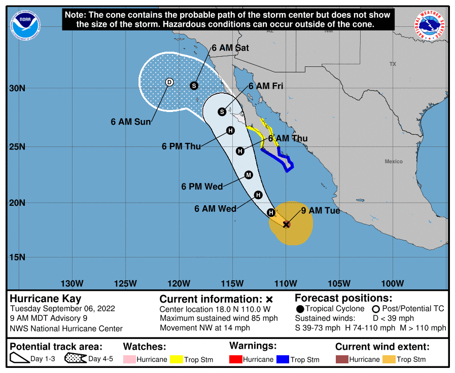
Hurricane Kay developed on Monday and is currently gathering strength well off the west-central coast of Mexico as it encounters the warm Eastern Pacific waters and favorable atmospheric conditions to host the strengthening.
Kay will continue to strengthen through midweek as the hurricane moves generally northward with a slight northwesterly component to the track. As Kay moves north, it will bring impacts to the Baja Peninsula midweek through late this week, potentially into the upcoming weekend.
There are some questions on the exact track—just how far east Kay will move. A slight jog farther east would bring even more impacts to the Baja Peninsula whereas a farther west track would lessen the impacts, although impacts would still be realized. Remember that impacts can be felt a couple of hundred miles away from the center of hurricanes.
The track will also play an important factor in the intensity of Kay. If Kay tracks farther east and encounters any land, this would weaken the system whereas Kay's center not facing the high, dry terrain of the Baja Peninsula would keep Kay more robust, and longer.
As Kay continues to move northward throughout the week, the focus turns to what could happen as the system grows closer to southern California. The waters are colder farther north so Kay will eventually undergo a quick decline in intensity but not quick enough to limit impacts to southern California. At this time, the current track, intensity, and speed would allow for Kay's moisture, wind, and swells to impact parts of southern California late this week into the upcoming weekend.
While this is good news for the heatwave because it'll help lessen the intensity of the heat for some areas in southern California, the moisture could lead to some flooding, and strong winds could cause problems—we will get to those winds in a second. While moisture will increase rain chances for southern California, especially south of I-10, the favored areas to see the heaviest rain will be the eastern slopes and eastern foothills of the southern California mountains and even into the desert areas. This is because the flow brought in with Kay will force the moist air up the desert floor into the eastern slopes of the mountains creating areas of heavy rain for the east slope and even into some desert areas. This will lead to some areas of flooding. Even the eastern slope of the Sierras could get in on the moisture action over the weekend.
Those same winds could be a concern for the western slopes of the mountains and inland areas near the west slopes. Because those moist winds, that are generating the rain for eastern areas, will actually enhance and dry out a little as they come through the gaps and down the western slopes. This will create a pseudo-Santa Ana wind event for the western slopes and foothills of the mountains in southern California which could increase the fire danger for these areas. Luckily, despite the Santa Ana concerns, there will be a higher chance for precipitation than normal with the mid and upper-level moisture streaming in from Kay so hopefully, this combats the Santa Ana concern.
There are still big questions about how much moisture could fall in southern California but right now areas south of I-10 have the best chance to see rain and the eastern slopes and eastern foothills have the best chance to see 1-3 inches of rain with isolated higher totals. This will increase the chance of flooding, along with debris and mudflows late Friday through early Sunday. The counties that will see the biggest impacts are San Diego, Imperial, Riverside, Orange, and San Bernardino. This is where there's the best chance to see the heaviest rain. But even Los Angeles county could see impacts along with Ventura, and Santa Barbara along with the east-facing slopes of the Sierras for southern and central California.
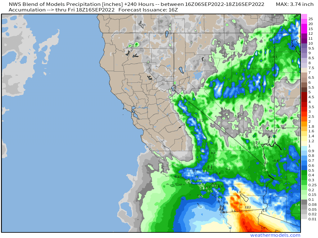
As mentioned, winds could gust up to 40-50 mph on the western slopes and western foothills and in the gap areas for southern California.
There will also be the potential for increased swells and rip currents along the southern California coast this week making dangerous conditions for beachgoers who are trying to escape the extreme heat this week.
Kay will gradually turn west away from California this weekend and a landfall WILL NOT occur in southern California. As Kay turns west, it will continue to weaken over the cooler waters of the Pacific. This is a unique system and typically hurricanes turn away from California before they get too far north so there is still some uncertainty in this forecast. Please keep checking back for updates.