Ian Coming To Georgia, Carolinas, and Mid-Atlantic Next
Hurricane Ian will continue to wreak havoc across the Florida peninsula Wednesday tonight and most of Thursday as it slowly treks northeastward across the Florida peninsula. Ian's center should move off the Florida east coast sometime Thursday evening/night.
I foresee Ian packing a punch, especially across eastern and southeastern parts of Georgia and much of South Carolina later this week into the weekend. I sort of get a sense that residents may be underestimating Ian's potential impacts.
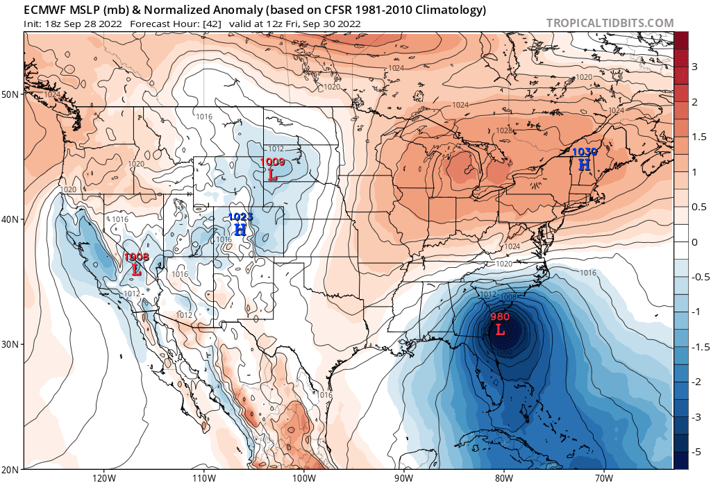
First, anomalously high pressure is currently building into the Great Lakes on the backside of a sharp trough that's currently digging into New England and the Mid-Atlantic. As Ian makes its way into northeast Florida, a tight pressure gradient will set up across southeast Georgia and lower South Carolina, starting tomorrow. This will result in a prolonged period of strong, gusty winds well before Ian ever makes a second landfall.
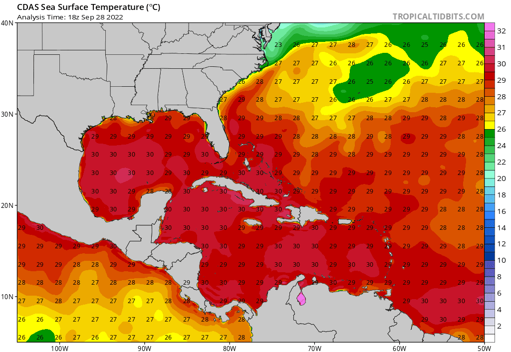
Secondly, as Ian emerges over the Atlantic, even if partially, it will regain access to heat energy from the ocean. Even though sea surface temperatures are marginal along the immediate northeast Florida, Georgia, and Carolina coasts, Ian may move far enough offshore to temporarily overlap with the warm Gulf stream. The map below shows the warmer tongue of high sea surface temperatures offshore the Southeast coast (sorry that this is in Celsius!).
Vertical wind shear will at least be moderate, something that's usually a hindrance to tropical cyclone intensification, but like today, Ian will move into a favorable position relative to the jet stream that may allow it to unexpectedly intensify further.
While over the water Thursday night into Friday, Ian will probably try to re-strengthen into a hurricane, despite the wind shear.
Impacts
Given Ian's size, along with strong high pressure moving into New England, this will set the stages for a prolonged period of strong winds and storm surge. The National Hurricane Center has Ian's second landfall occurring just after 2 pm on Friday in the lowest part of South Carolina. I agree that landfall will probably occur in South Carolina. However, Ian may feel the effect of the departing trough a little longer and manage to make landfall further up the South Carolina coast and later in the afternoon or evening on Friday.
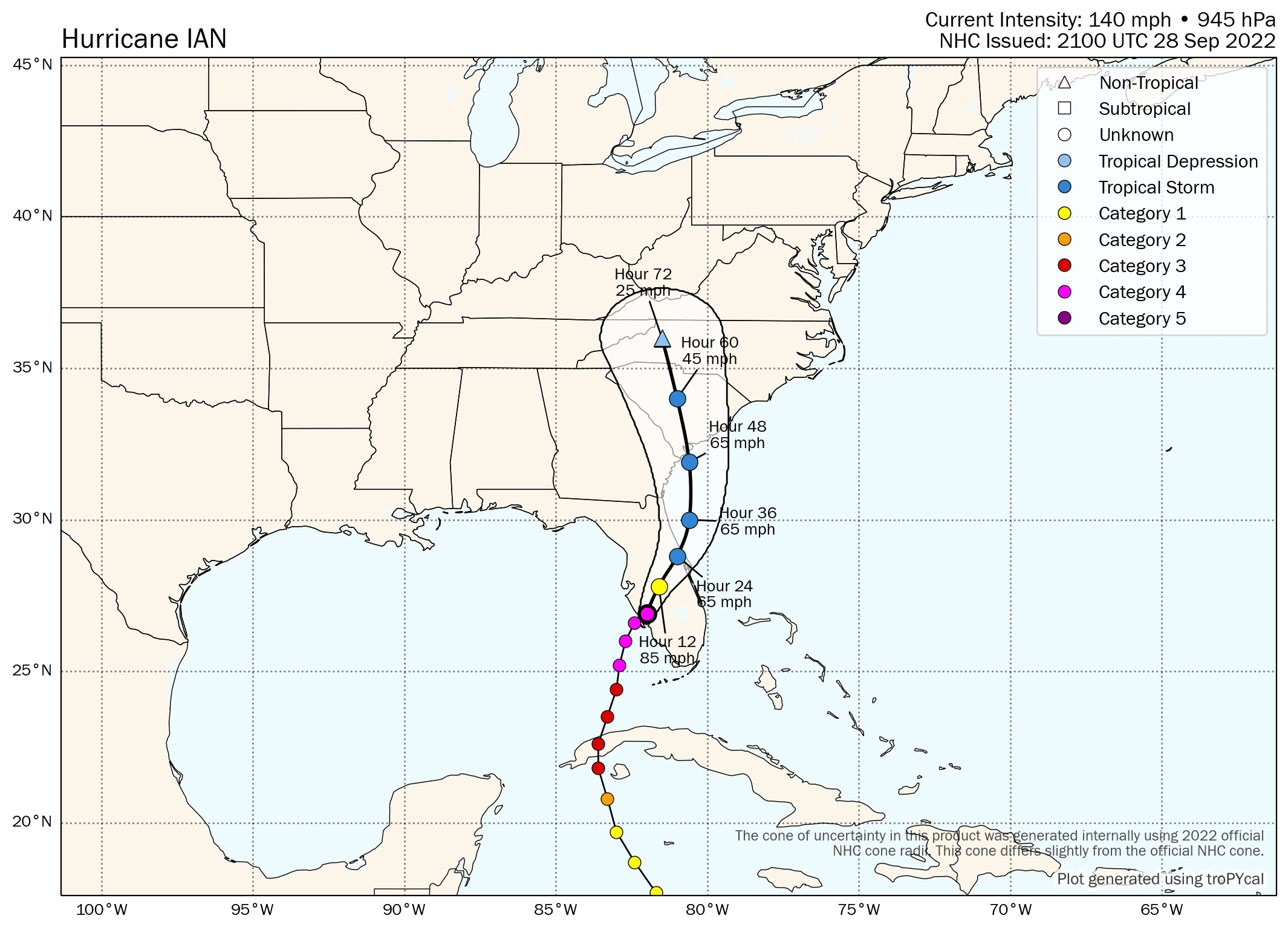
Latest Ian Forecast from the National Hurricane Center – Wednesday evening
If you're located in southeast/eastern parts of Georgia and into the Carolinas, plan for potential power outages due to wind, especially Friday into Saturday. Much of southeast and far eastern Georgia, most of South Carolina, and southeastern and south-central parts of North Carolina will probably experience at least tropical storm-force gusts. Even the Virginias may get in on some gusty winds over the weekend. Hurricane-force winds are to be expected at and closer to the Georgia and South Carolina coasts near and to the right of Ian's center.
Along with the big storm-surge risk as far north as the North Carolina coast, flooding due to heavy rainfall will pose an additional risk. The Carolinas, Virginias, and even into the remainder of the Mid-Atlantic will experience potentially heavy rainfall. There will likely be a sharp cut-off in the higher rainfall amounts somewhere in eastern parts of Georgia, maybe even close to the Georgia/South Carolina border. So right now, Atlanta is pretty much near the hit-or-miss zone.
Below are the projected rainfall totals over the next 5 days. Notice that a widespread area of 4-6 inches of rain will likely fall with local amounts potentially being considerably higher. The Mid-Atlantic should rack up the rainfall totals as well, because Ian's low pressure will probably stick around through early next week, long after it weakens.
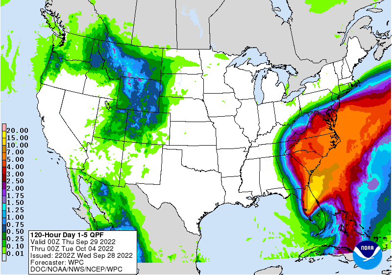
5-Day Rainfall Forecast – September 28-October 3, 2022
Please continue to follow us on Firsthand Weather throughout this event. If you're in Georgia, please consider following our North Georgia Facebook page. If you'd like to get our weekly newsletter, which we plan to start back soon, don't forget to subscribe!