Ian to make landfall as a strong category 1 hurricane today in South Carolina
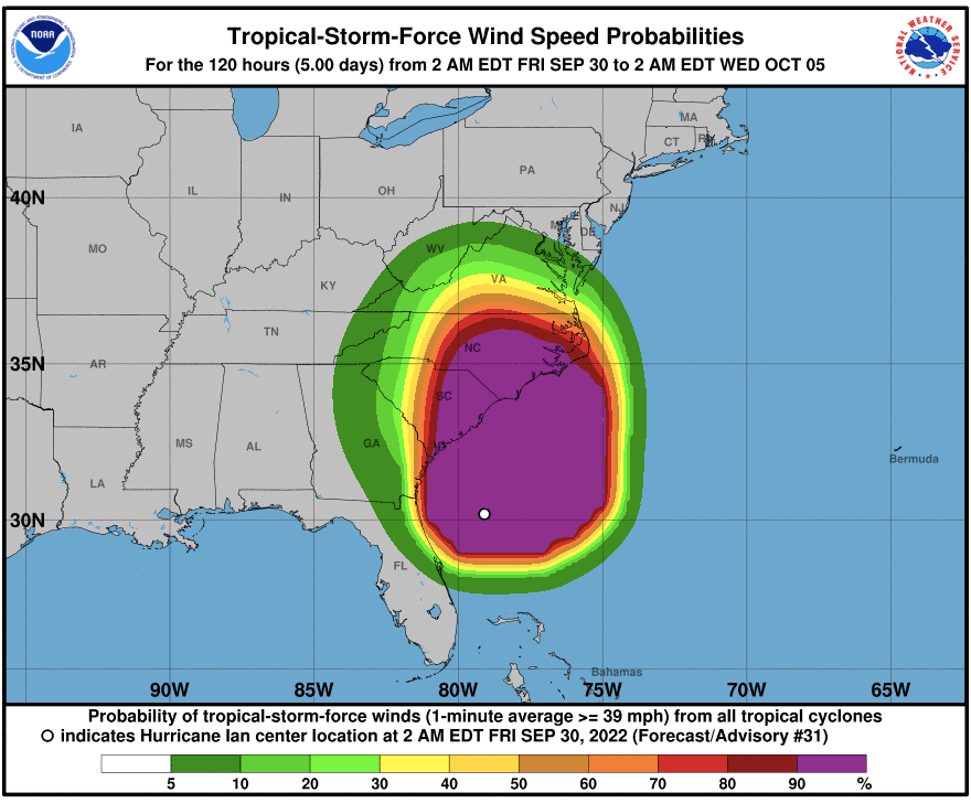
Ian has intensified into a strong category 1 hurricane with maximum sustained winds of 85 mph. As Ian begins transforming from tropical to extratropical (just jargon meteorologists use so don't focus on this, impacts will be the same), the wind field has expanded outward from the center of Ian. This means more people see more winds. Hurricane-force winds extend 70 miles outward from the hurricane's center with tropical-storm-force winds extending a whopping 485 miles.
The hurricane will maintain its intensity upon landfall so not much fluctuation (strengthening or weakening) is expected before landfall. The current movement is north at around 9 mph, which will carry Ian into the South Carolina coast and eventually inland today. Landfall is expected Friday afternoon or early evening, Eastern. Because of this, Hurricane Warnings continue for the coast of South Carolina with Tropical Storm Warnings for parts of the Georgia coast and coast of North Carolina. Tropical Storm Warnings also extend well inland into eastern Georgia, South Carolina, and North Carolina. Ian will accelerate inland later today and begin the weakening process tonight into Saturday.
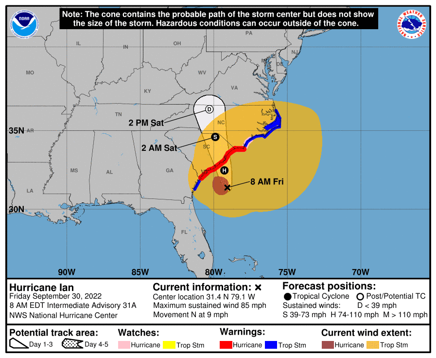
Significant impacts from Ian are expected for coastal areas of South Carolina and much of the Southeast coast with inland impacts too. Storm surge, wind, heavy rain and freshwater flooding, and tornadoes are all possible today into the weekend.
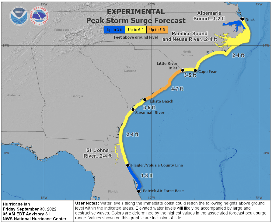
High tide plus storm surge from Ian will send a large storm from coastal northeast Florida all the way north into coastal North Carolina. Many of these areas will see a 2-5 feet storm surge with upwards of 7 feet for coastal South Carolina today.
The wind field is expanding with Ian so tropical storm force conditions are expected for much of the Southeast by this afternoon and evening with hurricane conditions along the coast later this morning and afternoon. The winds will lead to power outages and tree damage.
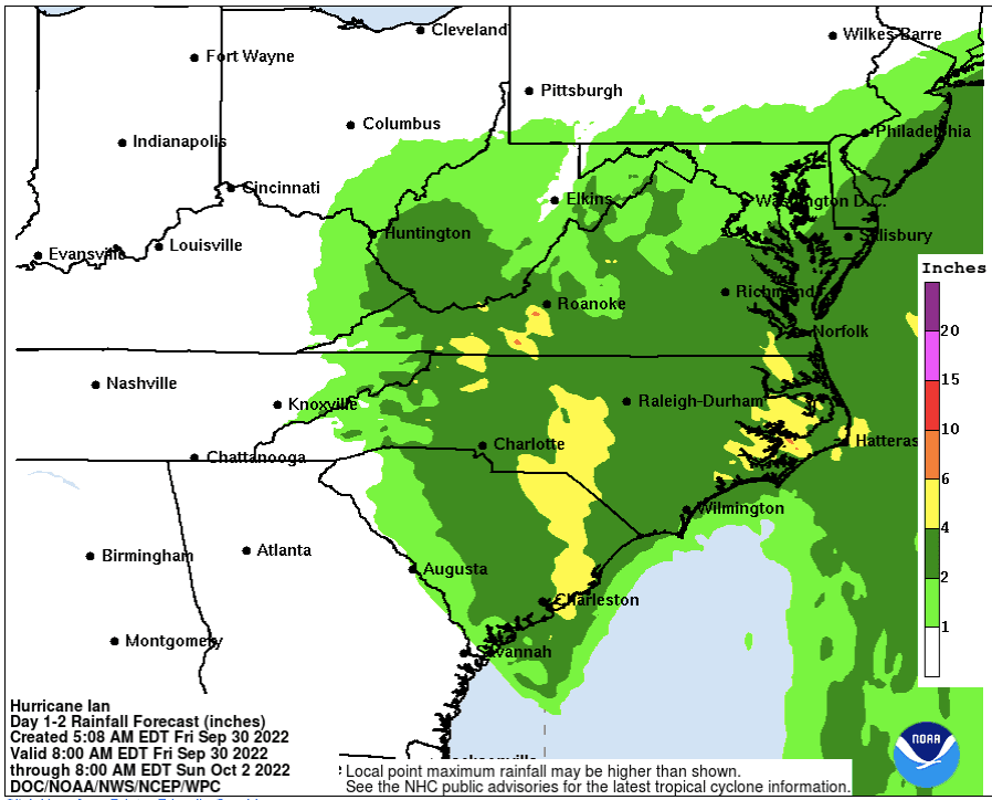
Heavy rain leading to freshwater flooding can be expected across parts of the Carolinas into the Mid-Atlantic where a widespread 3-6 inches are possible with amounts upwards of 8-12 inches in some areas. The heaviest rain will fall in northeast South Carolina with a second maximum from central South Carolina into North Carolina and southwestern Virginia today through the weekend.
Isolated tornadoes are also possible especially near the immediate coast today and possibly into Saturday.
Please stay weather aware and listen to your local officials and media for updates!