Update: Severe Storms Today
Not much has changed in regards to the severe potential for this afternoon into the evening hours. The Storm Prediction Center has expanded the slight risk area to include much of the central-body of Texas and southwestern Oklahoma. Warm, moist (unstable) air is present across much of Texas and southern parts of Oklahoma at this hour. A dryline is beginning to establish itself in far western parts of Texas. As the dryline becomes more defined, and advances towards locations just west of I-35, thunderstorms should develop just before sunset west of I-35.

Thunderstorm outlook from the SPC
Analyzing the parameters, there is adequate shear and instability for all modes of severe weather. The most intense surface based storms, which will have the greatest tornado threat, will develop just before sunset. The greatest tornado threat is across southwest Oklahoma and northwest Texas.


Tornado probabilities from the SPC
Once the storms advance towards the east later in the evening, they should quickly become linear in nature due to the shear profile. This would act to limit the tornado threat after the initial isolated activity develops into a squall line.

HRRR simulated reflectivity around sunset

HRRR simulated reflectivity this evening
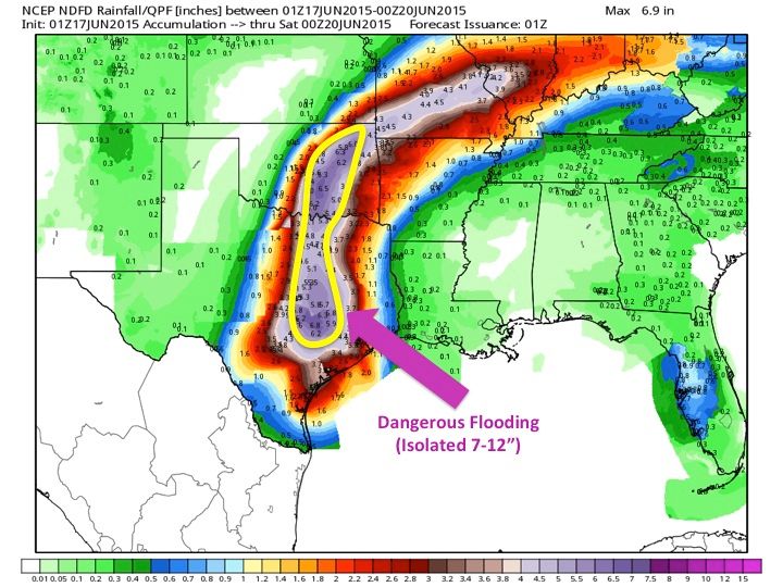
A secondary threat, especially in urban areas and low-lying areas, is flash flooding. The storms may dump very heavy rainfall in a short period of time, which could lead to isolated areas of flash flooding. The highest chance for flash flooding is in urban areas and eastern Texas. The Houston Metro may see flash flooding overnight on Sunday into Monday, so check the forecast closely if you must get on the roads Monday morning in the Houston area. Remember, do not ever cross a road that has water covering the roadway.

HRRR simulated reflectivity early morning hours

Rainfall forecast from the WPC