Will we finally get a break from the heat soon?
The heat has been ON from the Southern Plains to the southeastern U.S. coast. An expansive area of heat advisories and excessive heat warnings exist today across a majority of the nation’s southeast quadrant. Temperatures have been above average across much of the U.S., but it’s the above-average water vapor in the air that’s made temperatures feel considerably hotter. Thankfully, a pattern change will bring cooler and less humid air to eastern parts of the U.S. soon, though not for all.
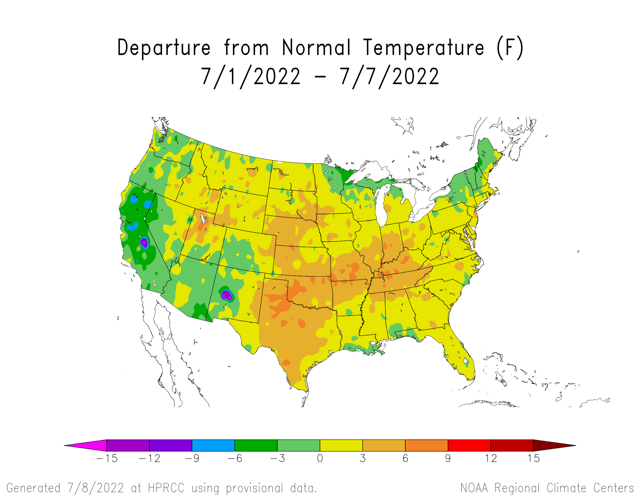
Temperature departures over the last 7 days: July 1-7, 2022; shading shows where temperatures will be above/below average
Large-scale ridging, which has dominated the pattern recently, will continue retrograding westward over the weekend into next week. Unfortunately, Texas and the Plains will continue experiencing excessive heat. However, areas across the Ohio Valley, most of Tennessee, and parts of the Southeast (generally from Alabama eastward) will have lower temperatures before the weekend ends. Now, remember, having lower temperatures in the middle of July is still hot in the Southeast, but we’ll take what we can get.
As the big ridge retrogrades west, surface high pressure will build into the Great Lakes region and Ohio Valley on the backside of a trough moving across eastern Canada. This storm system will usher in a cool front that should actually make it to the Gulf Coast by the weekend’s end. Now, temperatures will remain humid along the Gulf Coast and Florida, but the less humid and “cooler” air should move as far south as the northern Gulf coast states. Your weather apps are already probably showing a noticeable drop in the high temperature coming soon. That’s why.
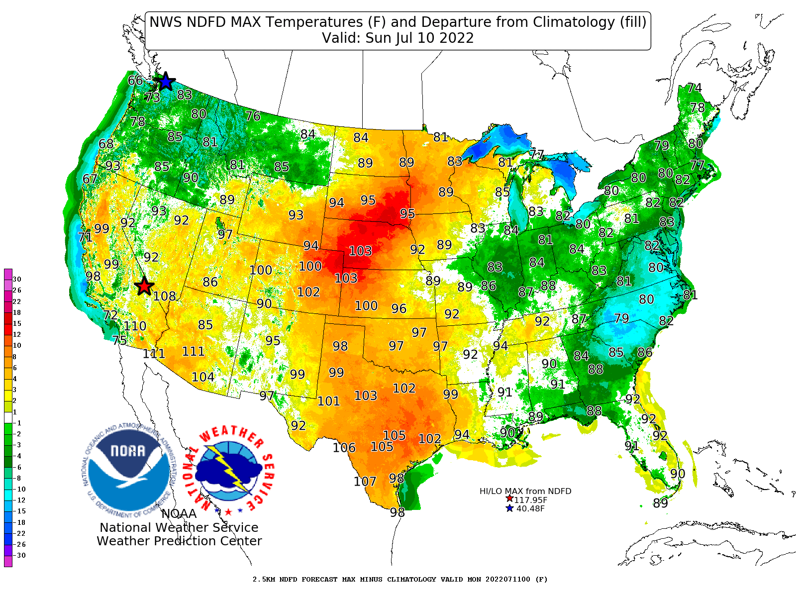
Predicted high temperatures for Sunday, July 10, 2022; shading shows where temperatures will be above/below average
Rain and storms will develop across the Ohio Valley, Tennessee Valley, and Mid-Atlantic over the next day or two, but once the front passes, conditions will clear. The Southeast won’t quite get the same result, especially across the lower half of the Gulf coast states and eastern Carolinas. With the front hanging around the Gulf Coast for a while, those regions will still favor daily thunderstorm activity, even this weekend, and humid conditions.
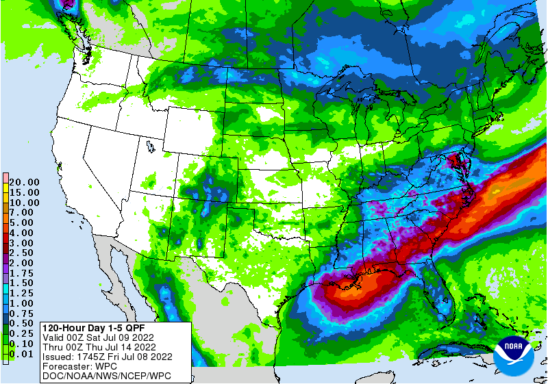
Expected 5-day rainfall totals: July 9-14, 2022
By the middle of next week, if not a tad sooner, winds from the south/southeast will re-moisten areas across the remainder of the Southeast and Tennessee Valley, bringing back those storm chances. To the north, troughing will favor at least one more intrusion of cooler and drier air as far south as the Ohio Valley and inland New England. The lower Plains will remain hot, and much of the western U.S. will have above-average temperatures next week.