Confidence increasing parts of the South will see snow this weekend
Firsthand Weather continues to monitor the potential for wintry precipitation for parts of the South later this week into the upcoming weekend. See the detailed article on the snow & severe weather potential on Friday & Saturday.
The latest guidance today continues to show this potential for a quick-hitting rain/snow mixture chance Friday into Saturday (spreading west to east) from northern Texas, Oklahoma, Arkansas, southern Missouri, far northern Louisiana, Kentucky, Tennesee, northern & central Mississippi, northern & central Alabama, northern Georgia, Upstate South Carolina, and North Carolina. There are still many questions but confidence has increased from low confidence to moderate confidence in the potential for snow for parts of these aforementioned areas late week into the weekend.
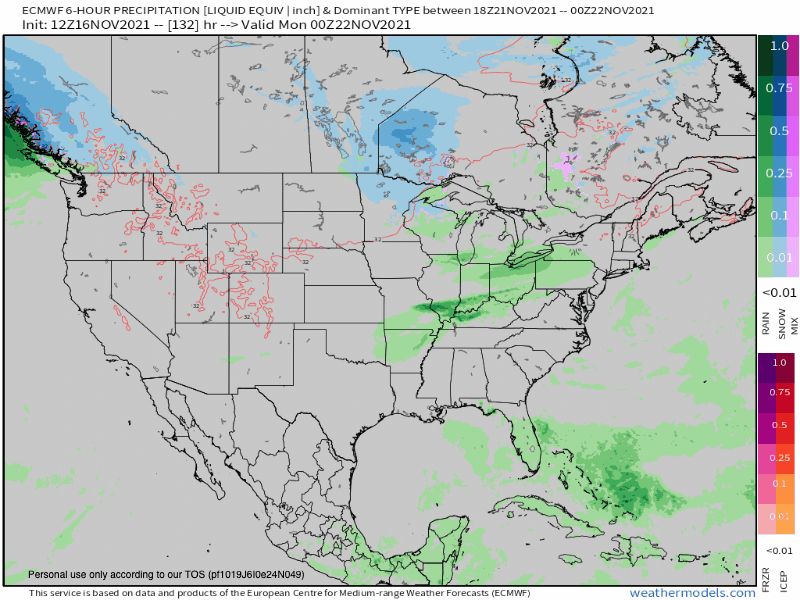
The European model over the past several runs has consistently shown this possibility of snow for parts of the Southern Plains, Mid-South, Tennesee Valley, and South late Friday into early Saturday, spreading into the Mid-Atlantic & Northeast over the weekend. The image below shows the latest animated run of the model from Friday through Saturday. The blue depicts snow while the green depicts rain. The darker the color, the heavier the precipitation.
The American model, like the European model, over the past several runs has also consistently shown this possibility of snow for parts of the Southern Plains, Mid-South, Tennesee Valley, and South late Friday into early Saturday, spreading into the Mid-Atlantic & Northeast over the weekend. The image below shows the latest animated run of the model from Friday through Saturday. The blue depicts snow while the green depicts rain. The darker the color, the heavier the precipitation. Join the Firsthand Weather Supporter Group for more details.

Again, while this forecast is not set in stone, confidence continues to increase that parts of the South will see snow Friday night into Saturday morning. The favored areas (for our followers in the South) will be Tennessee, northern & central Mississippi, northern & central Alabama, northern Georgia, and western North Carolina.
It’s too early to dive into the accumulation potential at this point. We do feel comfortable saying it’s possible there could be light accumulations, but this doesn’t appear to be a major winter storm. Warm temperatures leading up to the event, a short duration of wintry precipitation, marginal surface temperatures, and the snow possibly mixing with rain should mitigate how much snow potentially accumulates. Stay tuned for updates & join the Firsthand Weather Supporter Group for more details!