Tropical Storm Fred is expected to spread impacts into the Southeast
Tropical Storm Fred remains a low-end tropical storm Wednesday evening. The weakened state of Fred is expected over the next 24 to 48 hours as the system interacts with the high terrain of the Greater Antilles. Once Fred moves into the Florida Straits by the weekend, a gradual intensification is expected. The intensification will continue through the weekend as Fred moves across the eastern Gulf of Mexico (per the latest advisory from the National Hurricane Center).
Join the Firsthand Weather Supporter Group for a detailed breakdown of all the potential impacts from Tropical Storm Fred.
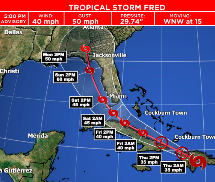
Current National Hurricane Center forecast track for Fred
Current thoughts are that impacts will spread into southern Florida Friday and continue to spread north across the state throughout the weekend as the center of Tropical Storm Fred moves north just off the west coast of Florida. Keep in mind, there is uncertainty with the track so this may need to be shifted farther west or farther east with time.
By late weekend into early next week, another landfall is expected in the Florida Panhandle. Again, there is uncertainty so this may change with time. Regardless of the exact track and landfall, the biggest impacts will be on the eastern side of the storm, so that should place all of Florida within a zone to see impacts from Tropical Storm Fred.
Those impacts will spread north into the Southeast late weekend into early next week as Fred moves north, eventually turning northeast, spreading the impacts into southern and eastern Alabama, Georgia, eastern Tennessee, South Carolina, North Carolina, and possibly into parts of West Virginia, and Virginia. It should be noted, these impacts are based on the current forecast track of Fred. Changes are likely to the track over the coming days, which will require updates to the areas that will see impacts.
Right now, the main concern is heavy rainfall across Florida and the aforementioned areas. The heavy rain will begin impacting southern Florida late weekend, spreading north across Florida throughout the weekend, and by early next week for the Southeast, with impacts possibly continuing across the Carolinas and Mid-Atlantic into mid-week. Areas of heavy rain are possible that may lead to areas of flash flooding. It is too early to dive into the specifics because there are too many questions, but we do have enough certainty to begin highlighting possible impacts for certain areas.
Southeast rainfall forecast next 7 days
Mid-Atlantic rainfall forecast next 7 days
Additional impacts are possible for parts of the Southeast. Join the Supporter Group for those details. There is also another tropical system Firsthand Weather is monitoring. Keep checking back for updates.